

2019 ·
2018 ·
2017 ·
2016 ·
2015 ·
2014 ·
2013 ·
2012 ·
2011 ·
2010 ·
2009 ·
2008 ·
2007
2006 ·
2005 ·
2004 ·
2003 ·
2002 ·
2001 ·
2000 ·
1999 ·
1998 ·
1997 ·
1996 ·
1995
 · What is RSS?
GGE News - 2012
- Google Street View: Been There, Done That
- Yun Zhang Receives the First Giuseppe Inghilleri Award
- A Change at the Helm
- Former GGE Professor Appointed to Order of Canada
- Anna Chrzanowski Receives Life Title of Professor of Technical Sciences from Polish President
- GGE Visits Rothesay High School Engineering Club
- GGE Hosts Geomatics Workshop
- GGE Grad Alumnus Wins the Prince Albert I Medal for Hydrography
- GGE Grad Alumnus Demonstrates New Ionosphere-Based Tsunami Tracking Technology
- UNB Launches Atmospheric Correction Service for Space Geodesy Applications
- GGE's Yun Zhang Awarded Almost Two Million Dollars for Research
- Dave Coleman Named President of GSDI Association at Annual Conference
- Spring 2012 Graduate Seminar and Student Technical Conference
- Annual GGE Graduate Dinner
- 2012 Undergraduate Technical Conference
- GGE's Yun Zhang Receives Research Council Award from Governor General
- Chinese Geomatics Delegation Visits GGE
- UNB to Help Train Europeans in Understanding Space Weather Effects on Satellite Navigation
Google Street View: Been There, Done That
 On August 19, 2012, Google's Street View crew visited UNB Fredericton with a tricycle and an SUV equipped with 360-degree cameras. This event created a certain amount of excitement on campus.
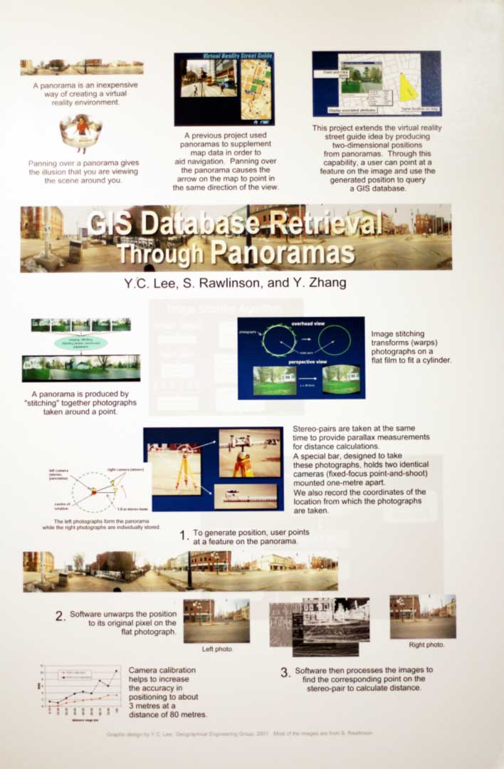
Creating a street view of a city or a university campus and putting it in a geographical data base allows people to tour the city or the campus without actually being there; it's a virtual tour. When Google pioneered its Street View technology in the United States in 2007, it seemed quite remarkable. But how original was the concept? Not very, it seems. The basic idea behind Street View was investigated back in 2000 in the Department of Geodesy and Geomatics Engineering at UNB by a research team led by Prof. Y.C. Lee. The research results were presented by then graduate student Stephen Rawlinson at the annual conference of the American Society for Photogrammetry and Remote Sensing in St. Louis, Missouri, in April 2001. The results were subsequently published in the conference proceedings and then in Mr. Rawlinson's master's thesis.
The image here compares GGE's street view (called panoramas) and Google Street View, for the same intersection in downtown Fredericton.
Wondering how street view works? Click here to see a poster produced by Dr. Lee in 2001 for GGE's 40th anniversary celebrations. It concisely shows the principles involved. The background technologies were (and still are) taught in GGE's mapping and GIS (geographical information systems) courses.
Google has been very successful with its technology, one that is very similar to that developed earlier at UNB. Currently, there are 20 petabytes of data for Street View, consisting of photos taken along five million miles of roads, covering 39 countries and about 3,000 cities. Did Google get the idea for Street View from UNB? We'll probably never know.
Yun Zhang Receives the First Giuseppe Inghilleri Award
![]() The International Society of Photogrammetry and Remote Sensing (ISPRS) has presented its Giuseppe Inghilleri Award for 2012 to GGE's Dr. Yun Zhang. The award was made at the recently held ISPRS Congress in Melbourne, Australia.
The International Society of Photogrammetry and Remote Sensing (ISPRS) has presented its Giuseppe Inghilleri Award for 2012 to GGE's Dr. Yun Zhang. The award was made at the recently held ISPRS Congress in Melbourne, Australia.
Dr. Zhang was the first person to receive the Inghilleri award, which is to be presented only once every four years to a nominee who has significantly enhanced the applications of photogrammetry, remote sensing, or spatial information sciences in the four years preceding the ISPRS congress. Dr. Zhang received the award for his important work in image fusion and automated pan-sharpening to improve the resolution of colour satellite imagery. He was recently featured in a Natural Sciences and Engineering Research Council of Canada video, "NSERC Presents 2 Minutes with Yun Zhang."
The Inghilleri award honours Giuseppe Inghilleri (1924-1982), a professor at the Politecnico di Torino, whose scientific work greatly enhanced the mathematical and statistical foundations of photogrammetry, surveying, and mapping science. The award consists of a certificate and 2,500 Swiss francs from the Italian Society for Surveying and Photogrammetry.
The ISPRS, founded in 1910 as the International Society for Photogrammetry, is a non-governmental organization devoted to the development of international cooperation for the advancement of photogrammetry and remote sensing and their applications.
A Change at the Helm
 On 1 July 2012, Prof. Marcelo Santos became the new chair of the Department of Geodesy and Geomatics Engineering, replacing Prof. Peter Dare who had been the chair for the past 10 years.
As part of the changing of the guard ceremony, Prof. Dare passed on the chairs' bottle of “medicinal alcohol” to be sampled only when facing a particularly trying circumstance that couldn't be handled in any other way. It hasn't been opened yet.
As Prof. Santos recalls the tradition: “A mysterious bottle of (deadly) buzz (Jamaican rum) has been passing from GGE chair to GGE chair for time immemorial. Nobody knows where this bottle came from, and nobody dares (no pun intended) to open it. Just a mysterious ghost sips the valuable liquid as the bottle level keeps subsiding even though it has never been opened.”
A baton was also physically as well as figuratively passed on as well. A gift from Terry Arsenault, the baseball bat will help the new chair to keep order in the house.
Click on the thumbnail image to get a better look.
Former GGE Professor Appointed to Order of Canada
![]() Dr. Salem Masry, a former professor in the Department of Geodesy and Geomatics Engineering and the founder and CEO of CARIS, the geospatial software company, has been appointed to the Order of Canada.
Dr. Salem Masry, a former professor in the Department of Geodesy and Geomatics Engineering and the founder and CEO of CARIS, the geospatial software company, has been appointed to the Order of Canada.
His Excellency the Right Honourable David Johnston, Governor General of Canada, made the announcement on June 22, 2012. Dr. Masry received the award "for his contributions as an innovator and entrepreneur in digital mapping technology." He was one of 70 new appointees to the order.
Recipients will be invited to accept their insignia at a ceremony to be held at a later date.
The Order of Canada, one of the country's highest civilian honours, was established in 1967 to recognize a lifetime of outstanding achievement, dedication to community, and service to the nation.
Dr. Masry joins GGE's Dr. John McLaughlin who was appointed to the Order of Canada in 2011.
Anna Chrzanowski Receives Life Title of Professor of Technical Sciences from Polish President
 Prof. Anna Chrzanowski, D.Sc., Ph.D., P. Eng. was awarded the title of Professor of Technical Sciences by the President of the Republic of Poland, Bronisław Komorowski, at a special event in the presidential palace in Warsaw on 31 May 2012. This honour is given to a scientist only after they have achieved major accomplishments in scientific research, in university teaching, and in industrial cooperation. Not to be confused with the designation "University Professor," the title "Presidential Professor" is given for life and only after decades of scholarly work and after the recipient has obtained a doctor habilitatus (essentially a second Ph.D. degree).
Prof. Chrzanowski holds a Ph.D. degree in mining geomechanics from the Technical University of Mining and Metallurgy in Krakow, Poland, and a D.Sc. degree in geomatics from the University of Warmia and Mazuria in Olsztyn, Poland. She is also a professor in the Faculty of Geoengineering, Mining, and Geology at Wrocław University of Technology in Poland, and a professor in the post-graduate Erasmus Mundus Minerals and Environmental Programme developed by a consortium of European Union universities and coordinated by Delft Technical University in The Netherlands.
Prof. Chrzanowski is an adjunct professor in the Department of Geodesy and Geomatics Engineering at the University of New Brunswick.
Click on the thumbnail image to look at photos taken during the ceremony.
GGE Visits Rothesay High School Engineering Club
![]() On May 30th, Prof. Marcelo Santos and Jay Woodyer visited the Rothesay High School Engineering Club (RHSEC), in Rothesay, New Brunswick. The RHSEC was recently placed under the spot light when they sent a balloon to "the edge of space."
On May 30th, Prof. Marcelo Santos and Jay Woodyer visited the Rothesay High School Engineering Club (RHSEC), in Rothesay, New Brunswick. The RHSEC was recently placed under the spot light when they sent a balloon to "the edge of space."
During the visit to the high school, the GGE staffers demonstrated some of the gear used by geomatics engineers, such as total stations and GPS receivers. And the students presented an overview of their own balloon launch activity showing that some of the work they had done was in the field of geomatics. "They were already doing geomatics even though they did not know it," commented Prof. Santos.
Such high school visits are an important part of GGE's outreach and recruitment effort, making students aware of an internationally acclaimed university program with great employment opportunities both in Canada and abroad.
GGE Hosts Geomatics Workshop
 Back in May, the University of New Brunswick's Department of Geodesy and Geomatics Engineering hosted a three-day workshop on geomatics for participants of the International Community-University Research Alliance (ICURA) project, Managing Adaptation to Environmental Change in Coastal Communities: Canada and the Caribbean or C-Change for short.
This project involves modeling the impacts of sea level rise for four Canadian and four Caribbean communities. The Canadian sites are Charlottetown, Prince Edward Island; Isle Madame, Nova Scotia; Iqaluit, Nunavut; and Gibsons, British Columbia; while the Caribbean sites are the Trinidad spawning ground for leatherback turtles; the Belize Barrier Reef; Bequia in St. Vincent and the Grenadines; and the city of Georgetown, the capital of Guyana.
The C-Change project is led by co-directors Dr. Dan Lane at the Telfer School of Management of the University of Ottawa and Dr. Patrick Watson, Director of the Sir Arthur Lewis Institute of Social and Economic Studies at the University of the West Indies (UWI), St. Augustine, Trinidad and Tobago, with the participation of a team of over twenty co-applicants, collaborators and community partners.
The purpose of the Association of Universities and Colleges of Canada-funded workshop at UNB was to transfer the technology—specifically the Coastal Collaborative GIS or CCGIS developed by Titus Tienaah at UNB—to our Caribbean partners from UWI led by Michael Sutherland. CCGIS manages local knowledge and volunteered geographic information (VGI) to support mapping and visualization of impacts. At the workshop, Aleasha Boudreau (University of Sainte Anne) described the use of CCGIS for managing historical community data in Arichat, Nova Scotia, and Don Forbes (Natural Resources Canada) discussed modeling sea level rise. GGE grad students Patrick Adda, Matt McAdam, and Andriy Rak made presentations on LiDAR, geodetic datums, and the legal impacts of using VGI.
Click on the thumbnail image to look at photos taken during the workshop.
GGE Grad Alumnus Wins the Prince Albert I Medal for Hydrography
 LtCdr. Aluizio Macel de Oliveira Jr. of the Brazilian Navy Hydrographic Centre and a graduate of UNB's Dept. of Geodesy and Geomatics Engineering, has won the Prince Albert I Medal for Hydrography - 2012.
The medal, which is awarded every five years, is named after Prince Albert I of Monaco (1848–1922), one of the great navigators and explorers of his time and the founder of the famous Oceanographic Museum.
Together with his co-author, Cdr. Izabel King Jeck, de Oliveira received the honour for the paper "Multibeam Processing for Nautical Charts," which appeared in the International Hydrographic Review (IHR) in November 2009. The paper was selected by the member countries of the International Hydrographic Organization as the best paper published in the IHR between 2007 and 2011.
The medal was presented by His Serene Highness Prince Albert II in Monte Carlo on 23 April 2012 during the opening ceremony of the 18th International Hydrographic Conference.
Click on the thumbnail image to get a better look.
GGE Grad Alumnus Demonstrates New Ionosphere-Based Tsunami Tracking Technology
 Led by Dr. Attila Komjathy, who received his Ph.D. from the University of New Brunswick in 1997, a team from NASA's Jet Propulsion Laboratory has demonstrated a technique that has the potential to significantly improve tsunami monitoring and warning.
The technique uses data from multiple Global Positioning System receivers on the ground to measure small perturbations in the ionosphere's electron density caused by a tsunami.
The changing sea level of a tsunami, even far from a coast, generates waves in the atmosphere that make it all the way up to the ionosphere, some 350 kilometres or so above the sea surface. Here, they disturb the electrons that affect the propagation of GPS signals. The disturbance is so small that ordinary GPS receivers do not notice the passage of the waves. However, with advanced software processing of the data collected by specialized receivers used, for example, by surveyors and geodesists, the waves can be visualized and used to track the progress of the tsunami.
The JPL team has dramatically demonstrated their technique for the devastating tsunami associated with last year's massive offshore Japanese earthquake. They used data from the more than 1,000 receivers of Japan's permanent GPS monitoring network. The propagating ionospheric waves can be clearly seen in a video the team has posted to YouTube: http://www.youtube.com/watch?v=iR6ZfG1gAms&feature=youtu.be
The video can also be downloaded from the GGE website.
An earlier report on NASA's tsunami-detection work can be found here: http://www.gpsworld.com/gnss-system/algorithms-methods/innovation-tsunami-detection-gps-4212
NASA is investing in research to obtain real-time GPS measurements from around the world so that researchers can integrate this technology into a global tsunami warning system. Additional potential applications might include the remote sensing of ionospheric perturbations generated by other natural hazards such as earthquakes and volcanic eruptions and human-made events such as nuclear tests.
Dr. Komjathy was one of the first to investigate the use of GPS signals to study the ionosphere. His pioneering Ph.D. research under Prof. Richard Langley was awarded a Governor General's Gold Medal.
Added 2012-June-12: A paper on JPL's work entitled "Ionospheric Signatures of Tohoku-Oki Tsunami of March 11, 2011: Model Comparisons Near the Epicenter" by Galvan et al. is being published by the American Geophysical Union's journal Radio Science with the digital object identifier: 10.1029/2012RS005023.
Added 2012-October-31: Read the associated story in the UNB Alumni News.
UNB Launches Atmospheric Correction Service for Space Geodesy Applications
 The Department of Geodesy and Geomatics Engineering at the University of New Brunswick announces the launch of the UNB Vienna Mapping Function (UNB-VMF1) Service. This service provides geodetic-quality corrections to the signal propagation delays caused by the troposphere—the lowest-most portion of the Earth's atmosphere—that are experienced by radio-based space-geodetic techniques such as GPS, other global navigation satellite systems, and very long baseline interferometry.
Although conventional procedures exist for modeling tropospheric delays, the new service promises corrections that approach one centimeter in accuracy by mathematically tracing the path of the radio signals through numerical weather models.
The service is based on the Vienna Mapping Functions developed by the Institute of Geodesy and Geophysics at the Vienna University of Technology. While tropospheric delay corrections using the mapping functions together with data from the European Centre for Medium-Range Weather Forecasts are already available, UNB will offer an alternative service with some distinctive advantages.
The mission of the UNB-VMF1 service is to:
- Support the geodetic and other scientific communities through research providing state-of-the-art corrections to the tropospheric delay for space-geodetic techniques.
- Improve the availability of tropospheric delay products with the addition of an independent source derived from independently-acquired data and independent ray-tracing algorithms.
- Achieve greater compatibility with other derived corrections, such as those for atmospheric pressure loading, using numerical weather prediction models.
The UNB-VMF1 service utilizes state-of-the-art numerical weather model datasets from the U.S. National Centers for Environmental Prediction and the Canadian Meteorological Centre, as well as state-of-the-art ray-tracing algorithms developed by GGE researchers.
The output of the UNB-VMF1 service has been approved as a provisional product by the directing boards of the Global Geophysical Fluids Centre and its parent organization, the International Earth Rotation and Reference Systems Service. The UNB-VMF1 service now begins a mandatory two-year evaluation period with the goal of obtaining full approval in time for the meeting of the European Geosciences Union in 2014.
Further details about the UNB-VMF1 service and datasets for corrections can be obtained from the official website: unb-vmf1.gge.unb.ca.
The research associated with the UNB-VMF1 service is supported by the Natural Sciences and Engineering Research Council of Canada.
GGE's Yun Zhang Awarded Almost Two Million Dollars for Research
![]() Prof. Yun Zhang has received almost two million dollars from the Atlantic Canada Opportunities Agency in the latest competitive round of the Atlantic Innovation Fund.
Prof. Yun Zhang has received almost two million dollars from the Atlantic Canada Opportunities Agency in the latest competitive round of the Atlantic Innovation Fund.
Prof. Zhang, Canada Research Chair in Advanced Geomatics Image Processing in UNB's Department of Geodesy and Geomatics Engineering, received the funding to further develop and commercialize digital image software technology with three times more colour sensitivity than colour image sensors available on the market today. Examples of where this technology could be used include cellphone cameras, webcams, digital cameras, and security cameras.
The award was presented at a special ceremony on May 22, 2012 at UNB's Wu Conference Centre attended by ACOA Minister Bernard Valcourt and Minister of Fisheries and Oceans and Minister for the Atlantic Gateway, Keith Ashfield.
Read the associated UNB news release here: http://blogs.unb.ca/newsroom/2012/05/22/unb-projects-receive-4-8-million/
CBC TV coverage of Prof. Zhang's award and his research can be viewed here: http://www.cbc.ca/video/#/News/Canada/NB/1305552294/ID=2238281353
Dave Coleman Named President of GSDI Association at Annual Conference
 GGE Professor and Dean of Engineering Dave Coleman was named President of the Global Spatial Data Infrastructure Association at the Global Geospatial Conference held in Québec City May 14-17, 2012. Founded over 15 years ago, the GSDI Association has a membership that includes national and regional mapping and land administration authorities, leading hardware and software companies, universities and non-government organizations from around the world. The purpose of the Association is to promote international cooperation in support of developing local, national and international spatial data infrastructures by encouraging and supporting the sharing of knowledge and experiences.
Since the first event held in Bonn, Germany in 1996, the Association's conferences have focused on supporting and attracting participants from both developed countries and emerging nations. With over 200 presentations, this year's event brought together under one roof the GEOIDE 2012 Annual Scientific Conference, the 3D GeoInfo Conference, the Canadian Geomatics Conference (CGC 2012), and the GSDI 13 World Conference.
Click on the thumbnail image to get a better look.
Spring 2012 Graduate Seminar and Student Technical Conference
 An interesting and informative Graduate Seminar and Student Technical Conference was held in the David E. Wells room (E-11) of the Engineering building, Head Hall, during the afternoon of Wednesday, April 4, 2012. The well-attended activity showcased nine graduate students making presentations of their selected topics previously submitted in formal papers. The seminar organizer, Shabnam Jabari, opened the event with prepared remarks and introductions including that of Dean David J. Coleman for the Faculty of Engineering. The first afternoon session included the following topics: quality assessments of volunteered geospatial data, detection of specific waterborne objects using a multibeam array, a study of geoidal undulations, vehicle velocity estimation using multispectral imagery, and advanced hydrodynamic modeling to estimate sound speed in a complex estuary. The chair of the first session was Evans Ralston. The second afternoon session began with the introductions of Bahram Salehi as the chair. There were four presentations covering object orientation estimation using magnetic and inertial sensing, environmental object attenuation reduction when using multi-sector sonar, proper integration of observations in hydrographic surveys, and 4D ionosphere tomographic modeling using GPS and GLONASS observations data.
A pair of judges evaluated each oral presentation and the corresponding papers in order to select the graduate student paper awards winners The judges, Professor Susan Nichols, GGE Director of Graduate Studies, and Adjunct Professor Anna Chrzanowski, reviewed the submitted papers and presentations at the conclusion of the sessions.
A post seminar reception with a food buffet was held for presenters, faculty, and guests. Professor Peter Dare, chairman of the GGE department welcomed all, announced the award decisions and made presentations. The awards were made possible thanks to the generous support of McElhanney Land Surveys Ltd., part of the McElhanney Canadian consulting company. Cash awards of $1000, $300, and $200 were presented to the first, second, and third place winners. The first place winner was Ian Church for his presentation “Estimating sound speed uncertainty within a complex estuary using hydrodynamic modeling.” Second place was won by Carlos Rubrio Marques and third place by Rodrigo Carvalho, making a clean sweep for the department's Ocean Mapping Group.
The seminar was a well-attended success due, in part, to the strong support of our sponsors: McElhanney, the Faculty of Engineering, and the Department of Geodesy and Geomatics Engineering. The support of GGE staff also contributed to the event's success.
Click on the thumbnail image to look at photos taken during the seminar.
Annual GGE Graduate Dinner
 The Geomatics Undergraduate Engineering Student Society (GUESS) hosted the annual Geodesy and Geomatics Engineering graduate dinner on Friday, March 30 at the Crowne Plaza Hotel. There were a total of 47 students, faculty, and staff present at the event, including special guests Professor Emeritus Angus Hamilton and his wife, Margaret. Highlights of the night included a few thoughtful words by Dr. Peter Dare, chair of the department; a lapel pin presentation to the May 2012 graduates by Dr. James Secord; and the annual grad “gag” gift exchange. The night finished off with the presentation of a gift to Dr. Secord in the form of a “Flagging Dispenser 3000,” made by GGE students enrolled in the course TME 3313 (Project Management).
GUESS would like to thank all of the students, faculty, staff, and special guests that made it out for a night of great food, lots of laughs, and well-deserved recognition. We wish all of the 2012 graduates good luck in their future endeavours and hope they all keep their “useful” gifts!
Click on the thumbnail image to look at photos taken during the dinner. (Photos: Norman Chai, 2012-March-30)
2012 Undergraduate Technical Conference
 The Dept. of Geodesy and Geomatics Engineering 2012 undergraduate student paper competition and technical conference was held on 22 March. It featured 20 presentations covering various aspects of geodesy and geomatics.
After opening remarks, the first session began at 9:30 a.m. This year's conference was slightly different from past years in that there were four sessions overall, and all 10 of the afternoon presentations were part of the Geomatics Engineering Student Paper Competition, co-sponsored by the New Brunswick Branch of the Canadian Institute of Geomatics (CIG).
There were 10 students competing for three top prizes. The first prize was $1000, awarded by the Canadian Institute of Geomatics. Second prize was $700, awarded by McElhanney. Third prize was $500, awarded by Midwest Surveys and a honorary mention of $100, was awarded by GGE.
Upon completion of all of the presentations, Dr. James Secord gave closing remarks and offered his congratulations to all contestants and presenters of the day. At this time the judges gathered to deliberate while the presenters, faculty, and guests gathered for refreshments supplied by the department and McElhanney.
After a difficult deliberation, the judges returned with their results. An honorary mention was first awarded by Dr. Peter Dare, chair of Geodesy and Geomatics Engineering, to Dane Frenette, whose paper was entitled “A GIS-based web application for the Geo cell.” Third prize was awarded to Brett Watson for his paper “Accuracy and precision assessment of atmospheric pressure loading applied to precise point positioning.” Second prize was awarded to Brad Eisan, for his paper: “Acoustic mapping of a moving iceberg in the Canadian Arctic.” Finally, first prize was awarded by CIG's Yves Léger to Tracey Peet for her paper “An assessment of the GOCE gravity models across Canada.”
The 2012 undergraduate student paper competition and student technical conference was a great success. This year's presentations were some of the best seen from the department.
Many of the day's events would not have been possible without gracious efforts and support of a select few people and sponsors. A huge thank you is extended to this year's judges: Yves Léger, GISP, GIS Manager, City of Saint John, and chair of the New Brunswick Branch of CIG; John Ellefsen, GIS Coordinator, City of Saint John; and Jody Blakely, P.Eng., CBCL Limited, Saint John [UNB Geomatics Engineering, 1997], secretary of the New Brunswick Branch of CIG. Also, many thanks for the support of our sponsors, the CIG New Brunswick Branch, McElhanney, and Midwest Surveys. Finally, a big thanks goes out to the Michelle Ryan for organizing the reception, as well as the Geomatics Undergraduate Engineering Student Society committee for putting on the lunch-time barbecue.
Congratulations to all of this year's presenters!
Click on the thumbnail image to look at photos taken during the conference. (Photos: Norman Chai, 2012-March-22)
GGE's Yun Zhang Receives Research Council Award from Governor General
 At a ceremomy at Rideau Hall on Monday afternoon (27 February), Prof. Yun Zhang of the University of New Brunswick's Department of Geodesy and Geomatics Engineering received one of this year's Natural Sciences and Engineering Research Council Synergy Awards for Innovation.
The Synergy Awards recognize partnerships in natural sciences and engineering research and development between universities and industry. They honour the most outstanding achievements of university-industry collaboration in the natural sciences and engineering. Winners receive a $200,000 research grant.
Prof. Zhang, who holds the Canada Research Chair in Advanced Geomatics Image Processing at UNB, received the award for his research with imagery taken by satellites. As stated in an NSERC backgrounder, "[the] satellites provide the ultimate "big picture" and make it possible to see what's happening in hard-to-reach places. However, it can be slow, expensive and difficult to process the vast amounts of data captured by satellite imagery. This team is working to solve this problem by creating complex algorithms that can fuse images from satellites with a processing speed and image quality that is the best in the world. It's also developing technology that makes remote sensing imagery look more like traditional aerial photography."
Prof. Zhang's research aims at solving challenging technical problems in remote sensing image processing that are of great benefit to industry. He has worked directly with PCI Geomatics in Toronto, a world leader in geo-imaging products and solutions, who have implemented a number of Dr. Zhang's innovations. Prof. Zhang teamed with PCI Geomatics for the NSERC award.
The awards ceremony was hosted by His Excellency the Right Honourable David Johnston, Governor General of Canada.
Read the associated UNB news release.
Click on the thumbnail image to look at photos taken during the ceremony.
Chinese Geomatics Delegation Visits GGE
 On February 16, 2012, a geomatics delegation from Jiangsu Province in the People's Republic of China visited GGE to explore leading research trends in remote sensing and GIS. Due to vast infrastructure development, geomatics has been booming in China at an unprecedented pace. The purpose of the delegation's overseas trip was to identity current and future leading geomatics technologies in the world and to place the province on the right track in purchasing modern geomatics equipment and software.
During the visit to GGE, Dr. Yun Zhang gave a presentation on new remote sensing technologies developed in his research lab and Dr. Emmanuel Stefanakis gave a presentation on the GIS work of his research group. GGE graduate students in remote sensing also participated in the meeting with the delegation. After the meeting, the delegation had a tour of the department.
Members of the delegation:
- Mr. Xu Dibao, President of the Surveying and Mapping Engineering Institute, Jiangsu Province
- Ms. Lin Xiuyu, Vice Director of Geographic Information and Foundation Center, Jiangsu Province
- Mr. An Xueshan, Vice Director of the Surveying and Mapping Market and Center, Jiangsu Province
- Mr. Chen Zemin, Vice Chief Engineer of the Surveying and Mapping Bureau, Jiangsu Province
- Mr. Xu Rongyu, Vice Director of Information of the Surveying and Mapping Bureau, Jiangsu Province
- Mr. Shen Jianrong, Vice Director of Land and Resources Bureau of Suzhou City
About Jiangsu Province:
Jiangsu is a province located along the east coast of China, neighboring Shanghai, with a population of 78.7 million (2010). With Nanjing as its capital, it is the province with the highest population density in China, except for the provincial level municipalities like Shanghai, Beijing, and Tianjin. Since the inception of economic reforms in 1978, Jiangsu has been a hot spot for economic development, and now has the highest GDP per capita of all Chinese provinces. It has been China's largest recipient of foreign direct investment since 2006.
UNB to Help Train Europeans in Understanding Space Weather Effects on Satellite Navigation
![]() The University of New Brunswick has become an official partner of a major European program to train the next generation of scientists and engineers to counter solar threats to satellite positioning and navigation systems.
The University of New Brunswick has become an official partner of a major European program to train the next generation of scientists and engineers to counter solar threats to satellite positioning and navigation systems.
One of the major threats to our ever-increasing dependence on GPS and other global navigation satellite systems (GNSSs) comes from the sun. Solar-related phenomena and their effect on the Earth's ionosphere, such as ionospheric scintillation, can be very disruptive, with serious consequences.
As we approach the next solar maximum in 2013, when ionospheric effects will be at their greatest, a network of internationally renowned experts, led by the Institute of Engineering Surveying and Space Geodesy (IESSG) at The University of Nottingham, are joining forces to help protect society from the effects of solar-related phenomena on GNSS signals. These experts will be training a new generation of young researchers as well as developing new research programs in the field of ionospheric perturbations and their mitigation.
At worst, solar outbursts can black out satellite signals altogether. They can also create positioning errors and rapid signal fading. These intermittent problems can impact all GNSS users including mission-critical and high-precision applications for air, rail, and marine transport, and even autonomous machinery in areas such as agriculture.
Testimony to the damaging effects of ionospheric interference were the serious service interruption and degradation caused by the so-called “Halloween storm” event that took place in October/November 2003, when one of the most intense solar flares ever was recorded: companies delayed high-precision land surveying, postponed airborne and marine surveys, cancelled drilling operations, and resorted to backup systems and commercial aircraft were unable to use GNSS-based systems for precision approaches.
TRANSMIT — Training Research and Applications Network to Support the Mitigation of Ionospheric Threats — is the first project of its kind in Europe. It is made up of a consortium of leading universities, research centres, and industry across Europe and as far afield as Brazil and Canada.
This €4m initiative is being funded by the European Commission (EC) through a Marie Curie Initial Training Network (ITN). ITNs are part of the FP7 People Programme and aim to improve the career perspectives of researchers who are in the first five years of their research career in both public and private sectors.
Marcio Aquino, coordinator and senior researcher in IESSG, said: “Europe lacks robust counter-measures to deal with these ionospheric threats. TRANSMIT will succeed in its aims because of the strong expertise and resources from its exceptional set of partners, encompassing both academic excellence and top-end users — including the aerospace and satellite communications sectors, GNSS system designers, service providers, major user operators and receiver manufacturers. The EC investment in projects like this confirms the importance Europe is giving to this new and exciting research area.”
The project will place Europe in a position to compete with state-of-the-art technology already being developed in North America.
A number of TRANSMIT fellows, the students selected to participate in the training program, will visit UNB for short periods to learn about the space weather data analysis tools and techniques developed by researchers in the Department of Geodesy and Geomatics Engineering and the Department of Physics on the Fredericton campus.