

2019 ·
2018 ·
2017 ·
2016 ·
2015 ·
2014 ·
2013 ·
2012 ·
2011 ·
2010 ·
2009 ·
2008 ·
2007
2006 ·
2005 ·
2004 ·
2003 ·
2002 ·
2001 ·
2000 ·
1999 ·
1998 ·
1997 ·
1996 ·
1995
 · What is RSS?
GGE News - 1997
- Ice Ages and the Earth's Orbit
- CIG Fredericton Branch December 1997 Paper Competition
- Sawsan A. Sharaf Joins Centre for Property Studies
- Michael Sutherland Awarded Centre for Property Studies Scholarship
- Fall 1997 GGE Student Conference
- Vaníček Awarded Visiting Fellowship
- GGE's Larry Mayer Keynote Speaker at Swedish Conference
- Congratulations Attila! Good Luck Katie!
- Institute of Navigation Prize Awarded to Chris Follett
- John McLaughlin New Vice-President (Research and International Co-operation)
- Dave Coleman New Department Chair
- Mike Collins Joins the Department
- Ahmed El-Sayed El-Rabbany
- Geodesy and Geomatics Grabs Lion's Share of UNB's NSERC Funding
- Ocean Mapping Group Garners $2-Million Contract
- Coastal Multibeam Training Course
- Alfred Kleusberg and Yola Georgiadou Farewell Gathering
- GGE Survey Camp II Students Map Montgomery Street Elementary School
- What to Do When Your Name is Ivan!
- Over the Bounding Waves
- Jobs, Jobs, Jobs - UNB's Surveying Engineering Graduates Map 35 Years of Success
- GPS for Geodesy - the School
- Geomatics Aids Duck Research at UNB
Ice Ages and the Earth's Orbit
 The November/December 1997 issue of Canadian Geographic magazine contains a two-page spread illustrating what causes ice ages. The images used by the magazine were taken from Orbits, an interactive computer program, that realistically models the earth's orbit, created under the direction of the Department's Larry Mayer, Chair in Ocean Mapping.
CIG Fredericton Branch
December 1997 Paper Competition
 The semi-annual CIG Fredericton Branch Student Paper Competition was held on December 4 in the ADI Multi-Media room in Head Hall.
As Branch members, several of our alumni judged the competition; namely, Wayne Walsh (Branch Chairman), Réjean Castonguay, Norman Coté, Roger Gaudet, Stephen Hartley, and Léo-Guy LeBlanc.
Click on the thumbnail image for details, 14 KB. (Photo: James Secord, 4 December 1997)
Sawsan A. Sharaf Joins Centre for Property Studies
 In November, the Department welcomed Sawsan A. Sharaf to our midst. Sharaf is the Training, Education, and Professional Development Coordinator for the Centre for Property Studies. The Centre, a multi-disciplinary research and training establishment, acquired the services of Sharaf to help in the development of special educational and training programs in property-related studies. Sawsan has B.Com., B.Ed., and M.Ed. degrees, and is currently an M.B.A. candidate. She has more than 20 years of experience in various positions in teaching, coordinating/managing projects, policy development and planning, curriculum design, prior learning assessment, transfer of credits, and distance education. We welcome her to our ranks.
Michael Sutherland Awarded
Centre for Property Studies Scholarship
Sutherland is from Jamaica and formerly worked in land administration with the Jamaican government. He first came to UNB in 1991 and completed a Certificate in Land Information Management. In 1995, he received an M.Sc.E. degree in Surveying Engineering. Sutherland has always been active in campus life, and this year he is president of both the UNB Caribbean Society and the department's Graduate Student Society. You can hear him on Tuesday nights on his UNB radio show promoting "classical" Caribbean music.
Click on the thumbnail image to get a better look at the wealthy scholar, 3 KB. (Photo: Harvey Studios, May 1995)
Fall 1997 GGE Student Conference
 On 24 and 25 November, the Department held its semi-annual student technical conference. Both graduate students and senior undergraduate students presented summaries of their research. Topics ranged from the expropriation of beach lands to a fly-through demonstration of a digital terrain model (DTM) for the Saint John River Valley, tracking oil spills using remote sensing, and the Department of National Defence's emergency mapping of the 1997 Winnipeg flood.
Click on the thumbnail image to get a better look at some of the participants, 52 KB.
Vaníček Awarded Visiting Fellowship
Petr's fellowship, held through the School of Surveying and Land Information at Curtin, will extend from mid-January until the end of March 1998.
Click on the thumbnail image to go to Petr's personal page.
GGE's Larry Mayer Keynote Speaker
at Swedish Conference
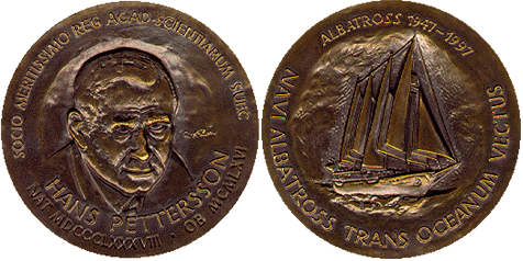 Larry Mayer, UNB's Chair in Ocean Mapping, was a keynote speaker at the conference Development of Paleoceanography as a New Field of Science held in August in Stockholm and Goteborg, Sweden. The title of Prof. Mayer's presentation was Carbonate Sedimentation in the Equatorial Pacific: A Non-chemist's Perspective. The conference, which commemorated the 50th anniversary of the Albatross expedition in 1947-48, was organized by the Royal Swedish Academy of Sciences. In honour of the occasion, the Academy of Sciences struck a new gold medal, "The Pettersson Medal", for excellence in Paleoceanography and awarded it to Gustav Arrhenius, a member of the original expedition. Bronze versions of the medal were awarded to the keynote speakers for their contributions to the field.
Click on the thumbnail image to get a better look at the medal, 83 KB.
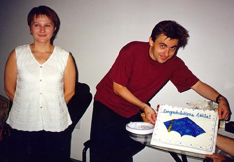
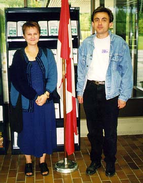
Congratulations Attila! Good Luck Katie!
 In August, Katie Komjathy hosted a student party, in Hungarian tradition, for her husband Dr. Attila Komjathy after he completed his Ph.D. oral defense. Held at Michael Sutherland's apartment, not only was the cake (30 KB photo) to celebrate Attila's becoming Dr. Komjathy, but the event served another purpose. Just days before, Katie and Attila had become landed immigrants in Canada. This picture(25 KB) was taken at Holten, Maine.
As "icing on the cake," so to speak, Atilla's dissertation, entitled "Global Ionospheric Total Electron Content Mapping Using the Global Positioning System, was judged UNB's best dissertation in science and engineering in 1997.
Soon, however, we had to bid Katie and Attila farewell as they took off for Boulder, Colorado, where Attila is a research associate at the University of Colorado's Colorado Center for Astrodynamics Research.
Attila and Katie are much missed; Attila as the senior graduate student mentor on E-level of Head Hall, and Katie as a research assistant who worked miracles in one (unnamed) professor's office. Good luck to you both.
Institute of Navigation Prize Awarded to Chris Follett
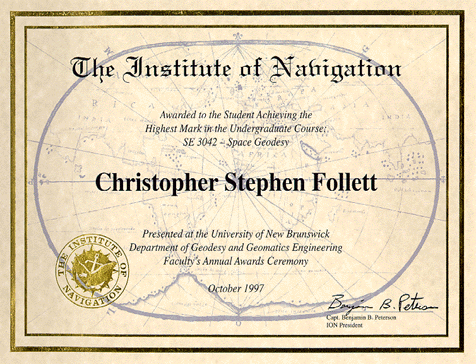 Chris Follett, a GGE student from St. John's, Newfoundland, was awarded The Institute of Navigation Prize this year. This prize is awarded to the student achieving the highest marks in the undergraduate course GGE 3042 - Space Geodesy. The prize, graciously donated by The Institute of Navigation, includes a certificate and a cheque for US$250.
Click on the thumbnail image to fetch the full-sized version, 111 KB.
John McLaughlin New Vice-President
(Research and International Co-operation)
John brings to his position both national and international consulting and research experience. Since 1992 he has been a consultant to the Instituto Libertad y Democracia in Peru, which is devoted to developing and implementing new approaches to property formalization and to building property infrastructure in the developing world. He is a partner in the non-profit property formalization company, Principal in Path to Property, which is active in Peru, Bolivia, and El Salvador. He has also been a consultant on land information systems and related disciplines to the Tennessee Valley Authority, the United States National Academy of Sciences, the University of Natal, the United Nations, the World Bank, the Canadian International Development Agency, various departments of both the federal and provincial governments, and the governments of the United Arab Emirates, Australia, Barbados, Qatar, and Nicaragua.
During his time as President of Champlain Institute (1989-1992), John developed an alliance among the public and private sectors, and the university community, in support of building a geomatics industry in Atlantic Canada. As a member of the Board of Directors of the N. B. Geographic Information Corporation, he aided this crown corporation to integrate real and personal property registration, property assessment, surveying and mapping, and GIS coordination in the province. John is also a co-founder of the new UNB Centre for Property Studies which was inaugurated on 19 June 1997. This centre is a multidisciplinary and interdisciplinary institute that builds on the university's expertise in engineering, law, forestry, and environmental management.
As he steps into this new position, we wish John well in his future endeavours.
Click on the thumbnail image to go to John's personal page.
Dave Coleman New Department Chair
Upon completion of his Ph.D. from the University of Tasmania, Dave joined the department in January 1993 as a research associate, and in 1996 he moved up a notch to senior research associate. On 1 July 1997, Dave became an associate professor.
Since 1993, he has either directed or been engaged as a specialist on major research projects dealing with spatial data access across dedicated wide-area networks and the Internet. As well, he has acted as a consultant to government organizations and private companies dealing with technical, management, and market issues associated with spatial data structuring and quality control, digital orthophoto mapping, on-line data distribution, and spatial data infrastructure.
Dave is a registered Professional Engineer in New Brunswick, and a member of both the Canadian Institute of Geomatics and URISA. He is the current chairman of the Canadian General Standards Board Committee on Geomatics, the Canadian delegate to Commission 3 of FIG, chairman of the FIG Commission 3 working group on spatial data infrastructure, and is an associate editor (GIS/LIM) of the journal Geomatica.
We wish Dave luck in his new position.
Click on the thumbnail image to go to Dave's personal page.
Mike Collins Joins the Department
Mike's experience and interests range over integrated analysis of multisource data, satellite oceanography, spatial/statistical analysis of remotely sensed imagery, and remote sensing in combination with GIS and with environmental monitoring.
In addition to academic accomplishments, Mike has over 10 years of industrial experience with the Earth Observation Laboratory of the Institute for Space and Terrestrial Science, in Toronto, and with McElhanney Surveying and Engineering, in both Vancouver and Calgary.
Mike brings with him teaching principles that complement those of the department. As Mike says, "Our long term goal must be to provide the students with a passion for the field of geomatics engineering, an ability to learn new technologies, and the ability to understand the implications of technologies in a larger context. The traditional linear teaching models cannot provide the education necessary for engineers to understand their roles in a society increasingly dominated by technology."
Ahmed El-Sayed El-Rabbany
El-Rabbany, who has came to us after a stint as a GPS systems specialist with Sokkia Inc., Canada, has research interests in stochastic modelling of multipath errors; datum determination, real-time kinematic GPS, and multipath errors; and satellite surveying and navigation. From 1993 to the present he has been a consultant to the Egyptian Ports and Lighthouses Administration.
Geodesy and Geomatics Grabs Lion's Share of UNB's NSERC Funding
The Department of Geodesy and Geomatics Engineering has the equivalent of 10 full-time faculty members, and these researchers received 12 NSERC grants.
Another honour for the department is that one of our faculty members, Wolfgang Faig, who is Dean of Engineering, received yet another NSERC grant. So what, you may be asking? Well, in the history of UNB and NSERC, he is the only dean of engineering to receive NSERC grants while holding that office.
The funding coming to the department will be used to support many different research projects. Some of those projects are as follows:
- To carry out precise positioning and navigation with GPS, one must take into consideration the effect of ionospheric refraction on the microwave signals travelling through the ionosphere. This research looks at the determination of global three-dimensional models of the ionospheric refractivity using an array of globally distributed GPS receivers and receivers on board low earth orbiting satellites. These models will increase our understanding of the processes in the upper atmosphere and how they affect GPS signals.
- The extraction of seabed information from high density acoustic sonar surveys has become increasingly important since the ratification of the United Nations Law of the Sea. Such information allows for the exploitation of seabed natural resources, such as oil and gas, aggregate and placer deposits, and bottom dwelling fisheries, and the monitoring of this exploitation.
- Digital close range photogrammetry, using off-the-shelf components, can be used for three-dimensional positioning purposes.
- Research into the paleoceanography and paleoclimate of the Pacific is an attempt to piece together a detailed history of the changes in climate and ocean conditions over the last 6 to 10 million years. This is being done to gain some idea of what the natural ranges of climate and temperature change have been over time so that a better understanding is gained of the possible impact of industrial activity on global change.
- The development of new methods and techniques for engineering surveys will find applications in mines and such large structures as dams.
- Robust modelling of GPS data for precision positioning and navigation. This research looks at four potential sources of error in GPS positioning to help users obtain the highest accuracies possible in precision positioning and navigation applications.
- The development of spatial data infrastructures. This research will examine the opportunities, strategies, and processes for re-engineering provincial land administration functions.
- The design of methodologies for re-engineering land records systems to meet land administration and mangement requirements. Part of the emphasis will be on developing new land administration systems to support land privatization in Eastern Europe.
- Geoid studies. Knowing the shape of the surface of the geoid means that we can take advantage of the cheap and accurate heights obtained from measurements to satellites, such as those of the Global Positioning System. This research will further refine the formulation of the boundary value problem, that leads to the solution and the numerical construction of the regional geoid, and improve the accuracy and computational efficiency of the numerical evaluation of an accurate regional geoid.
- The integration of hydrographic systems. The integration of technologies and systems (DGPS and electronic charts) applicable to hydrography will benefit three Canadian geomatics sectors: Technology companies, which supply hydrographic systems; service companies, which use such systems; and resource companies and government agencies, which use the results from such systems for resource management.
Ocean Mapping Group Garners $2-Million Contract
"With the data we collect, we produce a three-dimensional computer image that you can actually `fly' through, as though you were underwater moving across the ocean floor," explains Larry Mayer, holder of UNB's chair in ocean mapping in the department of geodesy and geomatics engineering. "You can see the distribution of materials - where there is sand and where there is mud - as well as fault lines and large man-made objects such as sewer pipes."
The Pacific Marine and Coastal Surveys team of the U.S. Geological Survey is gathering this type of information along the west coast of North America and around the Hawaiian Islands to better understand the offshore environment.
"The Santa Monica shelf off southern California was the first of three sites to be surveyed under the five-year contract," says Dr. Mayer. "We completed the first survey and maps of that area in October."
The maps identify the location of dump sites and give the U.S. Geological Survey information about the sites of potential mud slides in the eventuality of an earthquake. They also denote stable areas for possible waste disposal and show evidence of gas seeps, which may indicate fault lines.
"Knowing the seafloor material in an area also gives a good indication of what type of fisheries habitat you can expect," says Dr. Mayer, who is managing the project. The other member of the UNB research team is John Hughes Clarke. "John has written much of the software used to collect, edit, and clean up the data," says Dr. Mayer. "The U.S. Geological Survey came to us because we've developed software tailored to the processing of high-resolution multibeam sonar-mapping data."
In addition to its data-processing software and three-dimensional visualization products, it is the Ocean Mapping Group's experience with the digital, high-resolution swath-mapping method of data collection that has earned it a worldwide reputation.
"Traditional survey methods require a boat to pass over an area twice: once to measure the depth of the water, and a second time to get an acoustic picture of the sea floor," explains Dr. Mayer. "With modern swath-mapping systems, we can collect both measurements at once and cover a much larger area of the sea floor."
An acoustic picture of the sea floor is created by measuring the sound energy bounced back from the bottom. Harder materials send back more energy than softer ones. "This gives us an idea of what's actually down there," says Dr. Mayer. He adds that the data processing and map-making are normally done in real time on board the vessel.
For the Santa Monica shelf survey, the data were delivered to a shore-based centre where personnel from the U.S. Geological Survey and the Ocean Mapping Group processed each day's data and created three-dimensional visualizations. By the end of the three-week project, more than 500 square kilometres had been mapped.
"Projects like this bring money into Canada and allow us to put dollars into the research pot to develop new techniques," explains Dr. Mayer. The group's latest advancement is adding another information dimension to the three-dimensional maps or visualizations. "We're adding textures to the surfaces. This gives the viewer a much more vivid sense of depth and can provide additional information about seafloor properties."
UNB's eight-member Ocean Mapping Group conducts over $1-million dollars in contract research a year. It was involved in planning the Sable Island gas pipeline route for Mobile Oil, in conjunction with Jacques Whitford Nortech, as well as several fiber-optic cable routes.
Other contracts have included the $742,000 STRATFORM project for the U.S. Navy and base maps for the U.S. national marine sanctuaries at Monterey Bay and on Stellwagen Bank off Cape Cod. The latter was the largest shallow-water multibeam survey ever conducted to date.
The NSERC Chair in Ocean Mapping has 11 corporate sponsors in addition to the Natural Sciences and Engineering Research Council of Canada. It was established in 1992.
Coastal Multibeam Training Course
 The fourth course in coastal multibeam training was held 16-27 June at St. Andrews, New Brunswick. Under the auspices of the United States/Canada Hydrographic Commission (Coastal Multibeam Working Group), this course provides training in the theory, operations, and processing procedures involved in shallow-water hydrographic swath bathymetry. Designed for those already experienced in conventional (single beam) hydrographic surveying, with a knowledge of geodesy, positioning, and conventional tidal reduction methods, this course is comprised of three parts: Theory, field operations, and post processing.
Details are available for anyone interested in learning more about this course.
Click on the thumbnail image to view a photo of the class of '96, 114 KB.
Alfred Kleusberg and Yola Georgiadou
Farewell Gathering
 To bid a fond farewell to Alfred Kleusberg, the Department's chair from January 1995 until July 1997, and Yola Georgiadou, and to speed them on their way to new careers and opportunities in Stuttgart, Germany, a troop of bidders sallied forth to the Mactaquac Golf Club for a replete repast, some glad-handing, presents, and giggles.
Click on the thumbnail image to view scenes from the get-together, 137 KB.
GGE Survey Camp II Students Map
Montgomery Street Elementary School
 A topographic survey of the Montgomery Street Elementary School was undertaken as the project for GGE 2103, Survey Camp II, in May 1997 and also to provide the school with an up-to-date plan of their facilities. After gathering the field data electronically, PC-based software was used to process the data and to plot the plan in the New Brunswick mapping coordinate system. A full resolution copy of the plan in Adobe Portable Document Format (PDF) was also produced.
The students were required to connect to existing New Brunswick coordinated monuments by a local traverse. Elevations were determined using a Leica NA3000 digital automatic level with bar-coded staves and the horizontal traversing used Leica T1600 and T2000 electronic theodolites with add-on Leica Distomat EDMs (electronic distance measuring instruments). The field data was recorded in both Leica Rec Modules and a Leica GRE4 Data Recorder for later uploading into C&G; Survey Software on a PC for processing. The students then used C&G; to perform the traverse calculations and coordinate the detail measurements. After that, C&G; was again used to construct a DEM (digital elevation model) so that contours could be generated. The resulting contours were then combined with graphic files generated in both C&G; and AutoCAD to produce the finished plan (114 cm by 86 cm at a scale of 1:250) plotted on a Hewlett-Packard Draftmaster.
This is the third time that a Fredericton school has been mapped by GGE students. In previous years, students mapped the grounds of Garden Creek School and Albert Street Junior High School.
Camp II is coordinated by Prof. Alfred Kleusberg with the technical assistance of Howard Biggar.
Click on the thumbnail image to fetch the PDF version of the plan, 418 KB. You can use Acrobat Viewer's zoom facility to examine plan details.
What to Do When Your Name is Ivan!
Ford (B.Sc.E.(SE) 1981; M.Sc.E.(SE) 1990) was well equipped with both education and practical experience to take on the tasks of laying the groundwork for turning state-owned property into privately held property. Russia, and all the former republics of the Soviet Union, have had to move quickly to establish the legal frameworks, the land registries, the survey markers, and all the other procedures for recording and protecting property rights and interests.
Between October and December 1994, Ford worked in Russia as a consultant in land registration systems for Virginia-based American Cadastre, Inc. In January 1995, he began working with UMA Engineering of Edmonton, Alberta, and moved on to Ukraine as overall project manager, supervising a team of 13 Canadians and 45 Ukrainians on a similar land registration project. For most of 1996, and into February of 1997, he made the same type of contribution with UMA in Armenia.
Home and hearth beckoned Ford back to Fredericton at the end of February 1997. Always an excellent raconteur, Ivan will be able to "dine out" on his experiences for years to come.
Currently, Ivan is Manager of Customer Services at Universal Systems Limited here in Fredericton. He is in charge of 16 people (soon to be increased) who look after training new customers, lending help and support to all customers via a hotline, and testing new products. We wish him well in his new endeavour. (Photo courtesy of UNB Development and Public Relations)
Click on the thumbnail image for a better look at Ivan, 82 KB.
Over the Bounding Waves
 Each year, as part of the requirements of the GGE 4072 Hydrographic Surveying II course, a major laboratory exercise is run in St. Andrews, N.B., using the accommodations at the Huntsman Marine Science Centre and the wharf facilities at the St. Andrews Biological Station. In 1997, seven students and four instructors, in addition to Professor David Wells, participated in the exercise.
Click on the thumbnail image to view photos taken during the camp, 68 KB.
Jobs, Jobs, Jobs
UNB's Surveying Engineering Graduates
Map 35 Years of Success
"Graduates of our bachelor's program in surveying engineering are sought around the world," says James Secord, director of undergraduate studies for the department of geodesy and geomatics engineering. "Over the last 35 years we've graduated 635 surveying engineers, and nearly without exception, they've left with a job in hand."
Today, UNB's surveying engineers are working on land registration systems in Russia and Peru helping to put state-owned land into the hands of private citizens. Others are using the satellite Global Positioning System to monitor ground subsidence in Venezuelan oil fields and dam deformation in Pakistan, and in Thailand a graduate is providing high-tech surveying for forestry, agriculture and urban planning.
"Most students have a choice of opportunities," says Dr. Secord. "We find that employers come back again and again. This spring we've had four repeat companies from the U.S. that want to hire two or three grads each."
Mr. Breau credits the quality of the faculty with the program's success. "Most of the professors in the department of geodesy and geomatics engineering are the experts in their field," he says. "It's great because they bring their research and contract experiences into the classroom."
The worldwide reputation of the faculty is a drawing card for graduate students as well. The department currently has 72 master's and PhD students from 23 countries, including a number of officers from the Portuguese Navy.
As for Mr. Breau, he's had two offers from companies in Western Canada to conduct legal surveys for oil claims. "My goal is to get my legal land survey licence," he says. "I don't know which job I'll take. I think I'll wait and see...."
Release date: April 23, 1997
NRN: A605
Contact: Sandra Howland, UNB Office of Development & Public Relations,
phone (506)-453-4793, fax (506) 453-3599, e-mail
GPS for Geodesy
 The Second International School of GPS for Geodesy was held 2-8 March, in Delft, The Netherlands. The sponsors for the School are the International Association of Geodesy; the Netherlands Geodetic Commission; the Faculty of Geodetic Engineering, TU Delft; the Department of Geodesy and Geomatics Engineering, UNB: and the Survey Department of Rijkswaterstaat. The objectives of the School are to provide the information necessary to understand the potential and the limitations of GPS for geodesy, and to understand and/or develop software for the adjustment of GPS observations.
Geomatics Aids Duck Research at UNB
 Andrew Smith, a UNB biology graduate student, is examining the influence of habitat, common terns, and ring-billed gulls on nest site selection and nest succcess of greater scaup ducks. These nests are located on Grassy Island in the Saint John River near Oak Point. Until the late 1980s, the island was used to graze cattle. This provided an ideal habitat for the greater scaup duck which prefers to build its nest in clumps of vegetation away from dense forested areas. Now that cattle no longer keep the island's plant life under control, Smith feels that the greater scaup duck may be affected by this change in its preferred environment, and he is examining the nesting habitat of scaup and their association with the terns and gulls.
Smith began this project in the spring of 1995 with funding from the Fish and Wildlife Branch of the New Brunswick Department of Natural Resources and Energy. He set up a 100 metre by 100 metre grid on the island using forty, 8-foot posts. He recorded the nest locations relative to the nearest posts (distance and compass bearing). With the intention of producing a map of the gridded area, Smith needed greater accuracy than he had already obtained. In the spirit of cooperative education, he turned to UNB's world-renowned Department of Geodesy and Geomatics Engineering. Researchers in "G-squared-E", as the department is known, have played a major role in developing civilian applications of the U.S. military's satellite-based Navstar Global Positioning system (GPS). One of these GPS researchers is Paul Collins, a graduate student working on the development of GPS-aided aircraft navigation. Collins volunteered his services, two GPS receivers, and electronic distance measurement (EDM) equipment to help Smith with his nest mapping project. Together, the GPS and EDM equipment produced decimetre accuracy for the position of each post in the grid. From this accurate positioning, Smith was able to produce a map of the island showing the positions within the grid of the nests of the scaup duck relative to those of the terns and gulls. His work will help further the understanding of the nesting habits of one of New Brunswick's rarer breeding water birds.
Click on the thumbnail image for project photos, 391 KB.