

2019 ·
2018 ·
2017 ·
2016 ·
2015 ·
2014 ·
2013 ·
2012 ·
2011 ·
2010 ·
2009 ·
2008 ·
2007
2006 ·
2005 ·
2004 ·
2003 ·
2002 ·
2001 ·
2000 ·
1999 ·
1998 ·
1997 ·
1996 ·
1995
 · What is RSS?
GGE News - 2001
- Old Macs Never Die
- Polish Academy of Arts and Sciences Honours Adam Chrzanowski
- Engineering Faculty Announces Dean's List for 2000-2001
- Ocean Governance GEOIDE Network Meets
- Girls Day Out
- Fall 2001 Semi-Annual Technical Conference
- GGE Students at Atlantic Oil and Gas Innovation Forum
- Michael Sutherland Down Under
- Canadian Centre for Geodetic Engineering and Focus Corporation Form Strategic Alliance
- Dr. Yun Zhang Makes a Splash in Local Press
- Visiting Brazilian Student Wins Best Paper in Session at ION Meeting
- Welcome to Dave Carney
- First Nation Research on the Back of a Bike
- GGE (SE) 40th Anniversary Reunion
- Boundaries are Making Waves at GGE
- John Hughes Clarke Awarded Canada Foundation for Innovation Grant
- Geographical Data Acquisition
- UNB and UNESP (Brazil) Exchange Agreement Signed
- GGE Students Sweep Geomatics Atlantic Scholarships
- Kevin Pegler Wins First GEOIDE Research Scholarship
- Vaníček Awarded Professor Emeritus
- Katie Komjathy in Seoul, Korea
- GGE 2013: Practicum II - 2001
- Sam Ng'ang'a Winner of Board of Governors' Merit Award
- Establishment of the Canadian Centre for Geodetic Engineering
- Martin Winner of Canadian Engineering Memorial Scholarship
- NSERC News: UNB Engineering - Best in Canada! All Department Applicants Receive Grants
- Dave Wells Joins Navigator of the (U.S.) Navy Subject Matter Expert Team
- Three New Faculty Members Awarded NSERC Operating Grants
- Y.C. Lee's GIS for the Curious Now on CD
- 2001 Dineen Memorial Lecture
- Undergraduate Enrolment Up
- Samson Ng'ang'a Wins Geomatics Canada Scholarship
- Dave Taylor Distinguishes Himself at Paper Competition
- Technical Conference a Success
- GGE Student on Winning Junior Curling Team
- High-tech Navigation Subject of Dineen Memorial Lecture
- Pagiatakis Named Acting Director of Geodetic Survey Division
- Langley Named to NRC Committee
- Visitors from Laval
- Canadian Council of Land Surveyors Accredits our Program
Old Macs Never Die
 Starting way back in 1995 (see original story), the department has donated retired Apple Macintosh computers to Albert Street Middle School, Fredericton.
The latest donation, a Power Macintosh 8500/180, is used by the Physical Education Department to manage its curriculum as well as its many intramural and interscholastic sports - from badminton to wrestling.
Click on the thumbnail image to fetch the full-sized version, 50 KB.
Polish Academy of Arts and Sciences Honours Adam Chrzanowski
 Adam Chrzanowski was at the Polish Embassy in Ottawa on 3 December 2001 to receive the prestigious Diploma of Membership in the Polish Academy of Arts and Sciences. Mr. Pawet Dobrowski, Ambassador of the Polish Republic, presented Adam with his document of membership. Although the Plenary Assembly of the Academy elected Adam to become a foreign member, his election had to be approved by the President of the Polish Republic. The Academy restricts membership to 400 individuals, which puts Adam in very elite, but well-deserved, company.
Adam's nomination reflects his many important contributions to the field of surveying engineering, particularly to engineering and mining surveying, over his long career.
Click on the thumbnail image to look at photos taken during the ceremony and the certificate, 74 KB.
Engineering Faculty Announces Dean's List for 2000-2001
 One hundred and eighty-one students in the faculty of engineering at the University of New Brunswick in Fredericton have earned a place on the Dean's List for 2000-01. The dean of engineering, John Christian, announced that these full-time students attained a sessional grade-point average of 3.7 or an A- on at least 24 credit hours of course work to qualify for the list.
During the 2000-01 academic year, 973 full-time students were enrolled in UNB's undergraduate programs in chemical, civil, computer, electrical, geological, geomatics, and mechanical engineering.
One hundred and eighty-one students in the faculty of engineering at the University of New Brunswick in Fredericton have earned a place on the Dean's List for 2000-01. The dean of engineering, John Christian, announced that these full-time students attained a sessional grade-point average of 3.7 or an A- on at least 24 credit hours of course work to qualify for the list.
During the 2000-01 academic year, 973 full-time students were enrolled in UNB's undergraduate programs in chemical, civil, computer, electrical, geological, geomatics, and mechanical engineering.
The department's students receiving this accolade are:
Scott Adams and Jonathan Beaudoin, Fredericton, N.B.Congratulations to you all.
Katie Munroe, Nackawic, N.B.
Eric Quirion, Oromocto, N.B.
Karen Cove, Riverview, N.B.
Beth-Anne Martin, Wasis, N.B.
Robert Kingdon, Bridgewater, N.S.
Jason Bond, Judique, N.S.
Neil Kussat, Coquitlam, B.C.
Valerie Michel, France
Ocean Governance GEOIDE Network Meets
 On 30 November, the Ocean Governance GEOIDE network met again in Fredericton (see previous story). The main purpose of this meeting was to discuss the progress on the continental shelf delimitation and the New Brunswick administrative boundaries issues. Our local partners (Service New Brunswick, Department of Fisheries and Oceans, and CARIS) contributed actively to the discussion on the research problems and potential research spinoffs.
Click on the thumbnail image to get a better look at the participants, 34 KB.
Girls Day Out
 The halls of the engineering building were ringing with young voices on 29 November 2001. Over 100 young high school women had come to UNB to learn about careers in computer science and engineering. Here by choice rather than coercion, our guests were divided into groups of about 20, escorted to either computer science, civil engineering, or the two demonstrations we had running in the Department.
A fun time was had by all, and we hope to see some of these young people back in our department as undergraduates.
Click on the thumbnail image to look at photos taken during the visit, 115 KB.
Fall 2001 Semi-Annual Technical Conference
 Our most recent semi-annual student technical conference occurred on 28 November 2001. The graduate side of the event was organized by Richard Chan and Garret Duffy. Kevin Pegler organized the undergraduates. The first session, on GIS/LIM, was chaired by Tomas Beran, and the second session, on Ocean Mapping/GPS, was chaired by Sara Cockburn.
Click here for a complete schedule of events and abstracts of the presented papers.
Click on the thumbnail image to get a better look at some of the conference participants, 34 KB.
GGE Students at Atlantic Oil and Gas Innovation Forum
 Fifteen graduate and undergraduate students from the Department acted as rapporteurs and registration assistants for the Atlantic Oil and Gas Innovation Forum held in Charlottetown, P.E.I., on 14-16 November 2001. Sponsored by Natural Resources Canada (NRCan), the Forum was designed to help government and industry stakeholders to seek technical and policy innovation related to the oil and gas industry. The students recorded discussions at roundtables designed to expand on the innovation needs and answer certain pre-defined questions.
Click on the thumbnail image to get a better look at some of the GGE participants, 68 KB.
Michael Sutherland Down Under
 Michael Sutherland (Ph.D. candidate) has always had an unusual view of the world and certainly had difficulties in Brisbane in September keeping right side up.
Michael presented a collaborative paper on Hydrographic Education in North America (HENA). This is a joint venture among GGE (including Ocean Mapping and the Canadian Hydrographic Service); the Joint International Hydrographic Applied Science Program, offered by the University of Southern Mississippi's Department of Marine Sciences (with the U.S. Naval Oceanographic Office); and the University of New Hampshire's Center for Coastal and Ocean Mapping / Joint Hydrographic Center (with NOAA). Despite the amusement of the moderator, Michael says the Australian Institute of Surveyors took this joint venture very seriously as a way to develop collaborative programs in the future.
Canadian Centre for Geodetic Engineering and Focus Corporation Form Strategic Alliance
 On 18 September 2001, the Canadian Centre for Geodetic Engineering (CCGE) of the Department of Geodesy and Geomatics Engineering and Focus Corporation (www.focus.ca) of Edmonton, Alberta, signed an agreement to form a strategic alliance to carry out research and development collaboratively in geodetic and engineering surveys of high precision.
The alliance will facilitate access by Focus to new methods and techniques developed by CCGE through graduate courses and through personal contacts between CCGE and Focus. The alliance will provide CCGE with an additional source of funding to enhance their research capabilities and project scope. "We see the alliance as a win-win for both sides; we can enhance our research and development and provide skill sets that will complement Focus's core strength in geomatics, engineering, planning, and land management services," explained Dr. Chrzanowski, director of CCGE.
The alliance will provide consulting services to private and public sector clients involved in large engineering and geoscience projects. Services will include geodetic surveying, deformation monitoring and analysis, numerical modelling and prediction of ground subsidence, design of tunnelling and mining surveys, high precision alignment, and customized software development. Training and knowledge transfer will also be provided. "We are excited about the opportunity to work closely with CCGE and Dr. Chrzanowski," explained John Holmlund, CEO of Focus. "The alliance is consistent with our strategy to pursue partnerships that are conducive to further corporate growth and development," added Holmlund.
Click on the thumbnail image to get a look at the first display of the alliance's work, 39 KB.
Dr. Yun Zhang Makes a Splash in Local Press
Telegraph Journal, August 17, 2001Click on the thumbnail image to look at Dr. Zhang using his invention, 36 KB. (Photo courtesy of Jamie Roach, Sunniside Media, 2001-08-31)
Inventor seeks market for 3D
Innovation: New 3D imaging technology produces easy-to-use photographic maps
By Tali FolkinsAtlantic Business Regional Magazine, Aug/Sept, Vol. 12, No.4
Invent This, New Brunswick Scientists Know no Limit, Cover Story
By Sandra Phinney
Visiting Brazilian Student Wins Best Paper in Session at ION Meeting
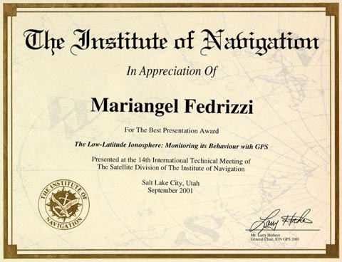 Mariangel Fedrizzi, a visiting student studying under Profs. Richard Langley and Marcello Santos in the Department of Geodesy and Geomatics Engineering, won a best-paper-in-session award at The Institute of Navigation's GPS 2001 meeting held in Salt Lake City last month.
Ms. Fedrizzi is a Ph.D. student from the Instituto Nacional de Pesquisas Espaciais (INPE), the Brazilian National Institute for Space Research. She is spending one year at UNB to study the use of GPS for examining the Earth's ionosphere.
Ms. Fedrizzi won the award for her paper "The Low-latitude Ionosphere: Monitoring its Behaviour with GPS" which was co-authored by Richard Langley, Attila Komjathy (NASA Jet Propulsion Laboratory/California Institute of Technology and UNB alumnus), Marcelo Santos, Eurico Rodrigues de Paula (INPE), and Ivan Jelinek Kantor (INPE).
Click on the thumbnail image to get a better look, 40 KB.
Welcome to Dave Carney
Mr. Carney brings to the University a wealth of experience in organizing, instituting, and managing programs and services. For instance, most recently he was with the Canadian Hydrographic Service leading a major study to redesign the organization, structure, and delivery of the national hydrographic program. Previous to this he was Director General of Policy and Planning with NRCan (for Geomatics Canada and the Geological Survey of Canada), providing management services for a multi-million dollar budget and 1600 employees. He has also managed the national topographic mapping program, the National Atlas of Canada, the aeronautical charting program for Canada, and the federal GIS Division.
Dave has won a number of awards, ranging from the Governor General of Canada's Medal for contributions to Canada and Canadians, the Gold Medal from the International Cartographic Association, and a U.S. Presidential Citation for geographic support to the Gulf War. He has chaired such gatherings as the federal-provincial Canadian Council on Geomatics, the federal interdepartmental Inter-Agency Committee for Geomatics (GeoConnections), the NATO Geographic Standards Committee, the National Working Group on Excellence in Geomatics, and the Geomatics Canada Revolving Fund Committee.
Dave hasn't found Crabbe Mountain on the map yet, but plans on doing some skiing during his sojourn with us. We all welcome yet another Dave to the fold (he makes number 5), and hope that this year will be of benefit to him as we know his presence will be to us.
First Nation Research on the Back of a Bike
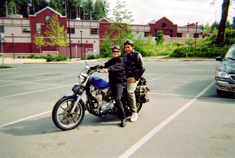 In August 2001, Ken Paul (M.Eng. candidate) and three others from the Department attended a workshop in Campbell River, Vancouver Island, B.C., on community mapping of the shore zone. This was in conjunction with one of the three new Department of Fisheries and Oceans/SSHRC networks: "Linking Science and Local Knowledge." This node is based at Simon Fraser University and Sue Nichols is a co-investigator.
Ken gave talks in Vancouver and Campbell River on the Eskasoni First Nation community charting project in the Bras d'or Lakes region of Cape Breton, Nova Scotia. In the photo, and definitely looking ready for the road, is Ken and Kelly Vooden, a Simon Fraser graduate student. They are on her Harley ready to leave for a visit to the Alert Bay First Nations community off the northeast coast of Vancouver Island.
Click on the thumbnail image to fetch the full-sized version, 36 KB. (Photo courtesy of Pat Gallagher)
GGE (SE) 40th Anniversary Reunion
Boundaries are Making Waves at GGE
 On 20 June, members of GEOIDE Project HSS#55 - Good Governance of Canada's Oceans: The Value and Potential of Marine Boundary Information - held a working group meeting in the Wells Multimedia Room in the Department. This is a multidisciplinary project involving lawyers, sociologists, economists, and both the Land Studies and the Ocean Mapping Groups at UNB, industry, and government, including Service New Brunswick and the federal Department of Fisheries and Oceans. The discussions were intensive and truly illustrate how different disciplines bring a variety of perspectives to the same topic. The term of the project is 18 months and runs until March 2002. Another face-to-face meeting is planned in September for the four universities involved to review the highlights of the research accomplished over the summer.
Click on the thumbnail image to look at photos taken during the meeting, 66 KB.
John Hughes Clarke Awarded Canada Foundation for Innovation Grant
 John Hughes Clarke was successful recently with his Canada Foundation for Innovation New Opportunities Fund Application. He will be using the money to explore the potential of multibeam sonar for mapping and monitoring decimetre-scale seabed changes. This will involve the acquisition of a Simrad EM3000 multibeam sonar, a Seatex MRU-6 roll, pitch, heave, and heading sensor, and an RDI monitor for acoustic Doppler current profiling and bottom velocity logging.
The instrumentation will be used to conduct research into innovative methods for integration, calibration, and navigation of multibeam bathymetric systems and to demonstrate the feasibility of this technology in a number of innovative applications of prime importance to the Canadian economy and environment. One application will be to satisfy the need for fine scale seabed monitoring. The sedimented seafloor can be a very dynamic interface, especially in the coastal zone. If a robust method to map and monitor the sediment water interface at scales of a decimetre could be developed it would allow researchers and engineers to better understand the effect of natural and man made influences on the seabed.
Another application will be to monitor the build-up and dispersal of organic debris under aquaculture sites. As salmon farming in New Brunswick was worth over $180,000,000 in 1998, more efficient methods to better monitor and characterize the benthic environment at operation sites is critical.
Dr. Hughes Clarke will also be looking at:
- the quantification of naturally occurring sediment transport rates and volumes; and
- the scour and deposition around man made structures (bridges, dams, breakwaters, underwater cable and pipes).
Geographical Data Acquisition
This is a book about techniques used in the acquisition of geographical data. The target audience is students and professionals using geographical information systems who want to go beyond the operation of the software and discover the general principles of how raw geographical data are acquired. ... this is a textbook written jointly by several people ... predominantly faculty members of the Department of Land Surveying and Geo-Informatics at The Hong Kong Polytechnic University.We congratulate both Dr. Chen and Dr. Lee (who, of course, is back with us at UNB) on their accomplishment.
UNB and UNESP (Brazil) Exchange Agreement Signed
 An exchange agreement has been concluded between the Universidade Estadual Paulista "Júlio de Mesquita Filho" (UNESP), of São Paulo, Brazil and the University of New Brunswick (UNB). This agreement is designed to encourage the exchange of students, faculty members, research fellows and visiting scholars, to facilitate inter-institutional study and research, faculty development and the sharing of joint research interests. The contact person from UNB is Dr. Marcelo Santos, Department of Geodesy and Geomatics Engineering and the contact person from UNESP is Dr. João Francisco Galera Monico, Departamento de Cartografia. The agreement will be in effect for the next 5 years.
GGE Students Sweep Geomatics Atlantic Scholarships
There is usually tremendous competition for these scholarships from university and community college students in institutions across the region, and we're sure this year was no exception. All three winners will be officially presented with their cheques at a special Awards Luncheon on Thursday, June 28th during the Digital Earth 2001 Conference at the Sheraton Hotel Fredericton.
We congratulate Karen, Greg and Kevin on their achievement.
Kevin Pegler Wins First GEOIDE Research Scholarship
A very limited number of GEOIDE NCE Research Partners Scholarships are awarded competitively each year to support graduate research in geomatics relevant to the aims of GEOIDE and its strategic goals. Competition is fierce and can include some of the top graduate students from the more than 25 universities across Canada now involved with the GEOIDE NCE. More information on this award program is available for anyone interested.
The award will support Kevin's research in developing a reconnaissance system for small recreational vessels using high-resolution remote sensing imagery in support of assessing marine search and rescue activities. An official announcement and the actual presentation of the scholarship was made at the Third Annual GEOIDE Research Conference held in Fredericton 20-22 June 2001.
Vaníček Awarded Professor Emeritus
 Although we are a tad tardy with our story, we would like to congratulate Petr Vaníček on his recently achieved Professor Emeritus status. The honorary rank was conferred during the UNB Encaenia ceremony on 17 May 2001. Petr doesn't seem to have reduced his workload at all, and continues his various projects around the world.
Click on the thumbnail image to look at photos taken during the ceremony, 71 KB.
Katie Komjathy in Seoul, Korea
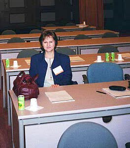 In May 2001, Katie Komjathy (part-time M.Sc.E. student) was invited to address the FIG General Assembly, meeting in Seoul, Korea, on the work she and Dr. Sue Nichols had completed for Swedesurvey and the Commission 7 on guidelines for women's access to land. The General Assembly adopted the work as FIG Publication No. 24 (http://www.fig.net/figtree/pub/figpub/pub24/figpub24.htm). The UN Food and Agriculture Organization is now revising this publication with Katie and Sue for translation. Katie also gave a paper at the Conference.
Katie, Attila, and son David have just moved to Pasadena, California, where Attila (Ph.D. 1997) has joined the Jet Propulsion Laboratory.
Click on the thumbnail image to get a better look, 20 KB.
GGE 2013: Practicum II - 2001
 From 2-8 May 2001 Practicum II (a.k.a. Survey Camp II) took place. This year the entire camp was based around the Musquash Estuary in southern New Brunswick. With glorious weather, all the goals of the camp were met. The tasks accomplished can be broken down as follows:
- Densification of the New Brunswick GPS Network. For this the students used Trimble GPS receivers. Seven additional new points were established by GPS traversing between one Canadian Base Network (CBN) and one New Brunswick High Precision Network (NBHPN) point. Two pairs of points were on beaches, which were to be used for the next stage of the work.
- The next stage was densification of GPS beach control. This required the coordination of points by traversing between the GPS control points using a total station. This work required some careful planning by the students as points were often under water at high tide!
- Topographic survey of the beach. For this the students used a combination of total station and reflectorless EDM (REDM). The REDM was crucial to the work as this enabled the inaccessible top of the cliff to be mapped.
- Mapping of the ordinary high water mark (OHWM). With the help of a licensed land surveyor of New Brunswick, the OHWM was mapped. This information will be valuable to a GEOIDE project of the Department. For this the students used a total station.
Sam Ng'ang'a Winner of Board of Governors' Merit Award
Establishment of the Canadian Centre for Geodetic Engineering
- basic research and development (R&D) and,
- commercialization and industrial applications.
Martin Winner of Canadian Engineering Memorial Scholarship
NSERC News: UNB Engineering - Best in Canada!
All Department Applicants Receive Grants
 Dean of Engineering John Christian was able to announce recently the results of the Natural Sciences and Engineering Research Council's 2001 Post Graduate Scholarships for first and second years of graduate study. On a per student capita basis, UNB's engineering faculty received more NSERC post graduate scholarships than any other engineering school in Canada.
All Department faculty applying for new NSERC grants this year were successful. Adam Chrzanowski received funding to purchase a robotic survey instrument for automated deformation monitoring. John Hughes Clarke won a grant for precise mapping and monitoring of seabed change research. Peter Dare obtained a grant to fund optimal and near-optimal design of Global Positioning System networks. The design and implementation of property information infrastructure is the topic of research being conducted by John McLaughlin with his new grant. Marcelo Santos has a grant to research optimal integration of geodetic techniques for positioning and precise navigation. Finally, Yun Zhang's grant will be used to develop algorithm and software for the detection of urban environmental changes using commercial high-resolution satellite imagery.
Congratulations especially to our new faculty (Dare, Santos, and Zhang) for being so successful in their initial submissions.
Dave Wells Joins Navigator of the (U.S.) Navy Subject Matter Expert Team
 At the end of March 2001, Dave Wells accepted an invitation from Rear Admiral, U.S. Navy, R. D. West, Navigator of the Navy, to join a newly constituted panel of experts on navigation. The "Subject Matter Expert Team" will be made up of about 20 individuals from private and public sectors, government, academia, and industry. Under the Navigator of the Navy within the Office of the Chief of Naval Operations, the panel will meet semi-annually to discuss the development of technical standards for navigation equipment, and the development/review of operational requirements and mission needs statements associated with navigational standards.
Congratulations to Dave for this latest honour.
Three New Faculty Members Awarded NSERC Operating Grants
Congratulations to our three newest faculty members on being awarded their first NSERC operating grants. All three were informed at the end of March 2001 that they would be receiving grants, which is an excellent batting average.
The principal objective of Dr. Peter Dare's research is to produce software to design optimal and near-optimal Global Positioning System networks, with an emphasis on the logistics. The result of the work will enable relevant surveys to be carried out cheaper and more quickly.
Dr. Marcelo Santos's research program is to develop and enhance algorithms, models and strategies, and software for optimal integration of data and ancillary information coming from various geodetic techniques. The research is targeted to geodetic positioning and precise navigation.
Dr. Yun Zhang's research will concentrate on algorithm and software development for the detection of urban environmental changes using commercial high-resolution satellite imagery. The goal of the research is to find new ways and develop effective tools to detect detailed changes and deliver near real-time information to environmental sectors to support informed decision making.
The award of an NSERC Operating Grant means that your peers from across the country have recognized you are doing - or have the potential to do - important research. Receiving the first such grant is an important milestone in the life of any researcher in science or engineering at a Canadian university.
Please see NSERC's press release.
Y.C. Lee's GIS for the Curious Now on CD
 GIS for the Curious has changed its name and become CARIS GIS for the Curious Edition 2. This multimedia guide to geographic information systems is the result of a project jointly funded by Geomatics Canada, CARIS, and UNB. It gives experience handling CARIS GIS software and provides an understanding of the capabilities of a geographic information system. Congratulations to Y.C.
2001 Dineen Memorial Lecture
 The 2001 Dineen Memorial Lectures, taking place in both Saint John and Fredericton on 20 and 21 March, were a great success. Dr. Philip Mattos of STMicroelectronics Ltd., in England, delivered the lecture on high-tech navigation. Both the afternoon and evening lectures were well attended by students, faculty, staff, and the general public.
Thanks to Dr. Yun Zhang, this year's Dineen Lecture Committee Chair, and Dr. Richard Langley, who helped pave the way for Dr. Mattos to make it here. Thanks to the President of the GGE Survey Society, Jonathan Beaudoin, and the President of the Engineering Undergraduate Society, Raman Verma, for their participation and organization. Thanks to Jill Cheverie, Michelle Weirathmueller, and Marshall Hatton for their help with the programs, coat check, on the doors, and overall security. Finally, thank you to Wendy Wells, GGE Administrative Secretary, and Heather Jones, Dean's Office. Without their attention to every detail, the lecture would not have been so successful.
Click on the thumbnail image to get a better look at Dr. Mattos and friends, 38 KB.
Undergraduate Enrolment Up
 The final figures are in and our 2000-2001 undergraduate enrolment is up by 11% over 1999-2000. We currently have 12 students taking the concurrent degree in Geomatics Engineering and Computer Science (B.C.S./B.Sc.E.), 82 students in the newly-revised four-year program, and the rest are exchange and diploma students, and students on PEP (Professional Experience Program), or 106 undergraduate students all totalled.
With this increased enrolment there has been a revival in the Undergraduate Survey Society. This year's Society president, Jonathan Beaudoin, has done a sterling job in attracting new memberships and involving the undergraduates in such activities as Hammyfest (alumni/ae will remember that fun-filled event), curling, bowling, a Christmas party, and now, at the end of the term, a Spring Banquet (attracting students from all years) and the year-end party for those graduating. Additionally, there are new jackets, t-shirts, and hats for sale.
Samson Ng'ang'a Wins Geomatics Canada Scholarship
Geomatics Canada scholarships are funded by Natural Resources Canada and administered by the Canadian Institute of Geomatics. A limited number of these prestigious scholarships, valued at $1,500 each, is awarded every year to students on the basis of high-quality academic performance and professional interests.
Dave Taylor Distinguishes Himself at Paper Competition
Technical Conference a Success
 In April 2001, the semi-annual student technical conference took place in the Dineen Auditorium of Head Hall. Organized by Ted Byrne, Tomas Beran, and Dr. Yun Zhang, 6 graduate and 11 undergraduate presentations were made. The categories of presentations were GIS/remote sensing; land information management; geodesy/GPS; and engineering applications/GPS.
Click on the thumbnail image to get a look at some of the presenters and organizers, 31 KB.
GGE Student on Winning Junior Curling Team
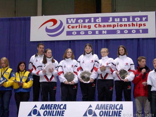 First-year student, Carol Webb (second from the left in top row in photo) was a member the 2001 World Champion Junior Women's Curling Team. This year's team was made up from the Canadian Junior Women's Champions from Prince Edward Island. Carol, who had competed on the New Brunswick Junior Women's Team, was invited to join the Canadian Champions to compete at the Worlds in Ogden, Utah. The world championships ran from 15-25 March. As a result, Carol has had to be away for most of the winter term but will be back in the Department for survey camp in May.
Congratulations to Carol and her teammates as 2001 world junior champions. (Photo: Nadine and Christian Saager. © CURLIT Curling Information Technology Ltd., 2001.)
Click on the thumbnail image to get a better look at the world champions, 43 KB.
High-tech Navigation Subject of Dineen Memorial Lecture
 The past, present and future of navigation is the subject of the 21st Dineen Memorial Lecture at the University of New Brunswick in Fredericton and Saint John. More ...
Pagiatakis Named Acting Director of Geodetic Survey Division
Langley Named to NRC Committee
Visitors from Laval
 The Ocean Mapping Group hosted three scientists from Quebec between 22 and 26 January 2001.
Click on the thumbnail image to get a better look at our visitors, 43 KB.
Canadian Council of Land Surveyors Accredits our Program
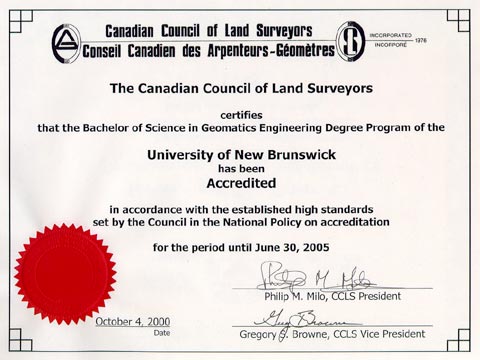 In March 2000, the process of having our cadastral surveying program re-accredited began with a visit from the accreditation team. In January 2001, we were informed that our program had been accredited for another five years. Thanks from the Department goes to Sue Nichols, who shepherded the office staff and the accreditation team through the process. A few comments found in the CCLS report follow:
After 40 years' existence, [the Department] continues to produce an excellent graduate equipped to enter the geomatics industry and professions.It was apparent from the interviews that each faculty member brought his or her unique enthusiasm and passion to their fields of responsibility.
The academic credentials of the faculty members are impressive.
Click on the thumbnail image to get a better look at the certificate, 35 KB.