

2019 ·
2018 ·
2017 ·
2016 ·
2015 ·
2014 ·
2013 ·
2012 ·
2011 ·
2010 ·
2009 ·
2008 ·
2007
2006 ·
2005 ·
2004 ·
2003 ·
2002 ·
2001 ·
2000 ·
1999 ·
1998 ·
1997 ·
1996 ·
1995
 · What is RSS?
GGE News - 1996
- CIG Fredericton Branch December 1996 Paper Competition
- Aquaculture Property Rights Research
- Geodetic Infrastructures in South America
- Retirement Party for Theresa Pearce
- UNB Co-Sponsors Geomatics Atlantic Conference
- WAAS Tropo Study Wrap-up Meeting at UNB
- Visiting Student Awarded Institute of Navigation Prize
- Personal GPS Receiver Applications in Search and Rescue
- Polish Order of Merit Goes to Adam Chrzanowski
- Sue Nichols in Mozambique
- Standards of Competence for Hydrographic Surveyors Meeting
- The Russians Are Coming, the Russians Are Coming!
- Vaníček 1996 Winner of J. Tuzo Wilson Medal
- 1996 B.Sc.E. Graduands
- Senior Paper Competition
- We're Number One!
- Woodstock High School Visits Department
- GPS for Geodesy
- High School Co-Op Student DevelopsWeb-Based UNB Class Locator
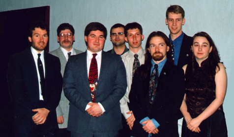
CIG Fredericton Branch December 1996 Paper Competition
 Eight senior surveying engineering undergraduates presented their technical reports in a paper competition on 3 December, sponsored by the Fredericton Branch of the Canadian Institude of Geomatics. The branch chair, Wayne Walsh [BScE(SE), 1986], officiated with judging by several branch members, including Norman Coté and Stephen Hartley [both BScE(SE), 1981].
Click on the thumbnail image for details, 31 KB.
Aquaculture Property Rights Research
 On a cold day at the end of October, Sue Nichols found herself on Passamaquoddy Bay, N.B. (139 KB). The exploratory trip was made prior to signing a contract with the New Brunswick Department of Fisheries and Aquaculture to conduct research on property rights, obligations, and liabilities in the aquaculture industry.
Click on the thumbnail image to fetch the full-sized version, 79 KB.
Geodetic Infrastructures in South America
 Researchers from the Department and from the Universidad Nacional de La Plata, Argentina, have been involved in a research and development program that has been funded by the International Development Research Centre (IDRC) in Ottawa. This program has promoted the innovative and cost-efficient use of Global Positioning System (GPS) technology to design a geodetic infrastructure for cadastral georeferencing in Argentina. It has also supported the development and management of geographic information. An integral part of the program has been to encourage a change in the technical culture of the geomatics community in Argentina through the use of informal strategic workshops. During 1996, three such workshops were held under the auspices of the provinces of Santa Fé and Chubut, Argentina; the International Institute of Aerospace Survey and Earth Sciences (ITC), The Netherlands; the Department of Geodesy and Geomatics, UNB.
The third workshop, held from 30 October to 4 November in La Plata, brought together participants from the public and private geomatics sectors of Argentina and other Mercosur countries (Common Market of the South consisting of Argentina, Chile, Brazil, Paraguay, and Uruguay). It was organized by the Universidad Nacional de La Plata and the Consejo Profesional de Agrimensura de la Provincia de Buenos Aires. It was sponsored by Commission 5 of FIG; the Consejo Federal de Catastro of Argentina; the Instituto Geografico Militar of Argentina; and the Federación Argentina de Agrimensores. Funding was provided by the IDRC with additional funds coming from the two organizing institutions. The theme of the workshop was El futuro de las redes de Control Geodesico en Sudamerica y los Nuevos Conceptos para los Levantamientos Catastrales. Participants debated the future of geodetic control networks in the region, and the delivery of a geodetic infrastructure to the users. As a result of the workshop, the Federal Council of Cadastre of Argentina agreed to convene a national meeting of cadastral and geodetic managers in Buenos Aires during the first week of December. This meeting was held at the Instituto Geografico Militar, and endeavoured to define the profile of a new geodetic agency for the nation.
Invited resource persons included Roger Gaudet, New Brunswick Geographic Information Corporation; Norman Beck, Geodetic Survey of Canada; and Larry Hothem, United States Geological Survey. Yola Georgiadou of the Department and Eduardo Fernández Falcón, Ohio State University, designed and coordinated the workshop.
Click on the thumbnail image to look at a few pictures from the workshop, 116 KB.
Retirement Party for Theresa Pearce
 On 19 October, Theresa's family, friends, and colleagues gathered at the Alumni Memorial Building to wish Theresa a happy retirement. Although Theresa had officially retired on 30 June, many of her well-wishers were then off on their travels, and October was the only time a majority of faculty and staff could be in town.
Click on the thumbnail image to go to the party page.
UNB Co-Sponsors Geomatics Atlantic Conference
David Coleman was the chair of the program committee for this year's conference, and assisted the conference chair, Chris Robbins (New Brunswick Geographic Information Corporation), in the overall planning for the event. Keynote speakers in the morning sessions included Dr. Michael Shiffer from MIT, and Dr. Terry Keating from Lucerne Associates. Other key speakers in the morning plenary sessions included Jean Thie and Barry Costello from Geomatics International, Alex Miller of ESRI Canada, Arnold Hougham of PCI Inc., Jeff Cole of Blue Marble Inc., and David Coleman of UNB.
Around the Conference...
On 8 October, Eugene Derenyi, John McLaughlin, and David Coleman acted as invited speakers to a pre-Conference Workshop on Advances in GIS and GPS, organized by the Association of New Brunwick Land Surveyors and the Fredericton Branch of the Canadian Institute of Geomatics.On 9 October, Geomatics Atlantic and UNB hosted a special event introducing geodesy and geomatics to 30 hand-picked high school students invited from four high schools in southern New Brunswick (Harvey, Nackawic, Oromocto, and Woodstock). Organized by Marta Wojnarowska, speakers included David Coleman, Richard Langley, David Wells, and Eugene Derenyi from UNB, as well as Phillip Milo from the College of Geographic Sciences , Lawrencetown, N.S. Finally, on the first evening of the conference, the Ocean Mapping Group arranged a special tour of its facilities for delegates.
WAAS Tropo Study
Wrap-up Meeting at UNB
 On 1 and 2 October, Paul Collins, an M.Sc.E. student in UNB's Department of Geodesy and Geomatics Engineering presented the results of a study carried out for Transport Canada Aviation (TCA) and the U.S. Federal Aviation Administration (FAA) on the modelling of tropospheric signal propagation delay for the future GPS-based Wide Area Augmentation System (WAAS). Also presented was a status report by Ph.D. student Attila Komjathy on his GPS ionospheric work which has application to the WAAS. The meeting, which was held in UNB's well-appointed Wu Conference Centre, was attended by staffers from Transport Canada, Natural Resources Canada (NRCan), MIT Lincoln Laboratory (LL), Information Spectrum, Inc. (ISI), the FAA's Satellite Program Office, and UNB.
Click on the thumbnail image to fetch the full-sized version, 147 KB.
Visiting Student Awarded
Institute of Navigation Prize
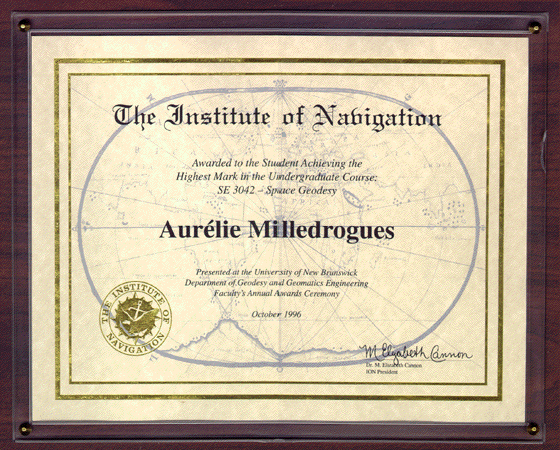 Aurélie Milledrogues, a visiting student from the Ecole Nationale des Sciences Géographiques of the Institut Géographique National in Saint-Mandé, France, was awarded The Institute of Navigation Prize this year. This prize is awarded to the student achieving the highest marks in the undergraduate course GGE 3042 - Space Geodesy. The prize, graciously donated by The Institute of Navigation, includes a certificate and a cheque for US$250.
Click on the thumbnail image to fetch the full-sized version, 145 KB.
Personal GPS Receiver
Applications in Search and Rescue
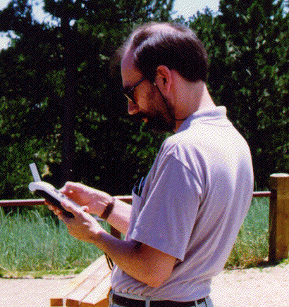 In September, David Wells introduced search and rescue personnel to hand-held Global Positioning System receivers. Held at the New Brunswick headquarters of the Emergency Measures Organization in the Victoria Health Centre, Fredericton, the demonstration attracted about 20 people from several N.B. detachments of the Royal Canadian Mounted Police, the Fredericton City Police, and the local search and rescue organization. In a hands-on demonstration, GPS receivers from a variety of manufacturers were used find the location of different points in the Health Centre parking lot.
Click on the thumbnail image to fetch the full-sized version, 114 KB.
Polish Order of Merit Goes to Adam Chrzanowski
Click on the thumbnail image to fetch the full-sized version, 81 KB.
Sue Nichols in Mozambique
 In July, Sue Nichols spent four weeks in Mozambique as a consultant to the Swedish International Development Agency (SIDA) to evaluate a land titling project. The goal of the SIDA program was to strengthen the capacity of Mozambique's National Surveying and Mapping Department (Direcção Nacional de Geografia e Cadastro (DINAGECA)) to carry out cadastral activities and topographic mapping. In this endeavour, a 1988 study had identified the need for DINAGECA to obtain and receive training on modern surveying and mapping equipment, and improved mapping and registration capabilities for land applications and titles. An emphasis was to be put on rural land, specifically family sector landholdings.
Nichols was asked to provide an evaluation of the SIDA program, mainly pertaining to how well the funding was being used, how efficient and effective the program was, and what impact there had been on customary family sector farmholders and on gender issues within the titling program. Nichols worked with an anthropologist, Dr. Clarissa Fowie, of the University of Natal, and a specialist in gender issues Mrs. Margaritta Mejais from Maputo. The group met with local and district planning people.
Click on the thumbnail image to fetch the full-sized version, 86 KB.
Standards of Competence for Hydrographic Surveyors Meeting
 Between 7 and 12 June, the Canadian Hydrographic Service and David Wells of UNB hosted the XIX Meeting of the FIG/IHO International Advisory Board on Standards of Competence for Hydrographic Surveyors in Fredericton. The 10 board members, representing hydrographic organizations in 10 countries, met to review curricula submitted by hydrographic and educational institutions. Established to encourage uniform high standards for the training of hydrographic surveyors, through development and maintenance of a model curriculum, the Board acccredits those institutions whose programs are judged to meet the standards of competence for hydrographic surveyors. UNB offers two certificates of competence in hydrographic surveying which were recognized by the Board in 1987.
Submissions that were reviewed this year came from Hogere Zeevaartschool, Amsterdam; the Naval Academy of the Colombian Navy; the Argentinian Navy; the Tunisian Navy; and the Department of Geomatics at the University of Melbourne, Australia. The Board also considered a project to reorganize the Standards. Phase one of the project consisted of reviewing the "essentials" part of the Standards. This was done and necessary amendments to the Standards were made.
Taking a break in the Board's deliberations, the members visited the Department and participated in a practical demonstration of the EM-3000 multibeam equipment on board the CHS launch Petrel.
Click on the thumbnail image to fetch the full-sized version, 85 KB.
The Russians Are Coming, The Russians Are Coming!
UNB's Geomatics Expertise Attracts Russians
 Russia is attempting to implement a land ownership system, and they are coming to New Brunswick to see how it can be done. In June, Dr. Sue Nichols and other members of the Department, along with the province's Geographic Information Corporation, hosted a Russian government delegation involved in privatizing the massive amount of state-owned property.
It was UNB's expertise in geomatics and the NBGIC's land database and registry system that enabled us to win the contract to train those involved in privatizing the land in how to run a land registry system. Between June and October 1996, about 60 Russian officials were given a customized series of lectures in the Department and hands-on experience at NBGIC. This exposure to our models and procedures will help them to formalize their own system.
Vaníček 1996 Winner of J. Tuzo Wilson Medal
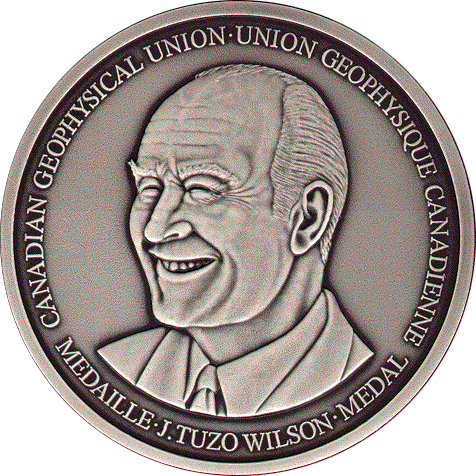 The Canadian Geophysical Union announced in May that the 1996 winner of the J. Tuzo Wilson Medal is Dr. Petr Vaníček. This medal is awarded annually by the Union in recognition of outstanding contributions to Canadian geophysics. Any individual nominated for this award must have shown excellence in scientific or technical research, in instrument development, in industrial applications, or in teaching. The citation by Mike Craymer and Vaníček's acceptance will be published in the next edition (Vol. 14, No. 2) of Elements, the newsletter of the Canadian Geophysical Union.
Click on the thumbnail image to fetch the full-sized version, 155 KB.
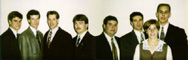
1996 B.Sc.E. Graduands
 On 22-23 May, the 167th Encaenia took place on the Fredericton campus. To celebrate the end of what could have been 4 to 6 years at UNB, on 12 April, the undergraduate Survey Society held the year-end banquet. At this event, the director of undergraduate studies, James Secord, presented departmental crest lapel pins to the graduands.
The photo shows some of the students expecting to receive their diplomas at this year's encaenia. Left to right: Timothy Kier, Michel McLaughlin, Andrew Laidlaw, Paul Grant, James Lutes, Rupert Brooks, Christopher Nicholas, and Janice MacRitchie.
Graduands missing from this photo: Kevin Coombs, Christopher Parsons, Moses Shamu, and Greg Skelhorn. Both Coombs and Parsons competed the cadastral surveying option.
Click on the thumbnail image to fetch the full-sized version, 61 KB.
Senior Paper Competition
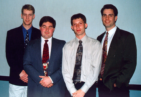 Since 1983, the Fredericton Branch of the Canadian Institute of Geomatics (CIG) has hosted a senior paper presentation competition at the Department of Geodesy and Geomatics Engineering. Each senior student must prepare a major technical report as part of their degree requirements. Presentations of these reports are made before the faculty and students of the Department, and four students are chosen to represent the Department in the CIG competition.
On 3 April 1996, the CIG Fredericton Branch heard presentations from the following students (left to right):
- · Chris Nicholas (from Maine)
- The Role of GPS and GIS in Intermodal Freight Transportation
- · Andrew Laidlaw (from Nova Scotia)
- The Role of the Private Citizen in the Property Assessment Process
- · James Lutes (from New Brunswick)
- Geometrical Analysis of Earth Deformation Using VLBI Data
- · Chris Korell (from Manitoba)
- Approaching the Next Millenium: Challenges and Issues Facing Land Surveying
Click on the thumbnail image to fetch the full-sized version, 73 KB.
We're Number One!
[UNB's] academic orientation is distinctly forward looking, with a solid liberal arts curriculum complemented by science, computer and engineering programs that are among the best in the country. ...New Brunswick's engineering strengths are further underscored by the achievements of its geodesy and geomatics department ... which is considered to be the best in North America. [Such a program] explains the university's enormous drawing power among international students... . The warm environment, coupled with academic excellence, are among the things that keep graduates singing the praises of the University of New Brunswick.
Woodstock High School Visits Department
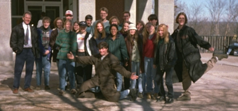 As part of the partnership agreement with Woodstock High School, about 30 students spent most of 27 February touring the Department's facilities and meeting the faculty and staff. The visit was to further increase the students' awareness of the geomatics profession and to help entice them to remain interested in mathematics and science.
The group received informal presentations from Dave Coleman (on geographic information systems); John Hughes Clarke (on geomatics and oceans); Yola Georgiadou (on department projects taking place in South America); and from Sue Nichols (on department projects in Eastern Europe). The students were then split into groups and visited the four laboratories in the department: Ocean Mapping, GIS and Photogrammetry, GPS, and Engineering Surveys.
The group photograph of students and their teacher, was taken outside the engineering building, Head Hall.
Click on the thumbnail image to fetch the full-sized version, 47 KB.
GPS for Geodesy
Click on the thumbnail image to fetch the full-sized version, 10 KB.
High School Co-Op Student Develops
Web-Based UNB Class Locator
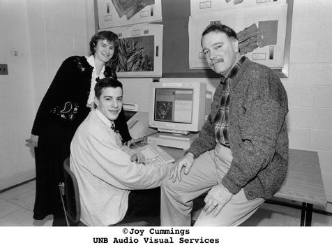 Craig Wood, a Grade 12 student at Fredericton High School, Fredericton, New Brunswick, Canada, has developed a Web-based class locator. Its development took place while Craig was completing his part-time co-op training program with the Department of Geodesy and Geomatics Engineering at UNB.
During his co-op training, Craig completed a self-paced introductory course in geographic information systems (GIS) using the CARIS GIS software developed by Fredericton's Universal Systems Limited. Using a previously digitized and structured map of the UNB campus, Craig refined an application within CARIS which enabled him to highlight different buildings in response to specific requests.
Combining this training with an introduction to the Internet World Wide Web (WWW) - and a few days of "Internet surfing" practice - it was decided that Craig would tackle a project which combined aspects of both geographic information retrieval and the Web. In this project, Craig designed a WWW application that would give newcomers to UNB the ability to locate, in advance, the buildings in which specific classes were to be held. Two items of information were required: a series of softcopy map files Craig generated using the CARIS GIS, and the 1995 official course timetable dataset for UNB's Fredericton campus. Craig designed the type of inquiry system he wanted to create, developed batch processes and interactive methods to edit the input datasets, introduced himself to the art of Hypertext Markup Language (HTML) programming, and then developed the necessary HTML scripts and inquiry screens required to implement his design.
In engineering terms, what did Craig Wood do? Craig saw a problem that needed solving. He looked at different ways to solve the problem, decided on a suitable method, and then pulled together the tools, information, and procedures needed to do the job. He designed his Web page, tested it under different conditions, and modified it where he thought it could be improved. That's what engineering is all about.
We think that Craig Wood has done a pretty good job (especially for a Grade 12 student) and, through his work, hope he has also received a better idea of the design, technology integration, and testing aspects of geodesy and geomatics engineering.
During his stay at UNB, Craig received advice and assistance from Marta Wojnarowska and Dr. David Coleman, in the GGE department, and Rob Murray in Computing Services.
At the end of the project, UNB issued a press release which included the impressions of some of the people involved.
To find out more about the interesting field of geodesy and geomatics engineering, contact:
The Chair
Department of Geodesy and Geomatics Engineering
Room E-54 Head Hall
University of New Brunswick
P.O. Box 4400
Fredericton, N.B.
Canada E3B 5A3
Phone: 506-453-4698 E-mail
Click on the thumbnail image to fetch the full-sized version, 57 KB.