|
Quick Page View
Highlights
Useful Links
|
|
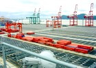
Gantry Crane Auto-Steering System
|
|
The crane control system – a key component of the port’s
management system – has been developed to improve container-handling
productivity and operational safety at a busy container terminal. It
comprises the anti-sway system, which helps operators accurately
position a crane’s spreader to grab containers; the position detection
system, used to identify and cross-check the positions of stacked/unstacked
containers; and the auto-steering system, which keeps the wheels of a
rubber-tired gantry crane (RTGC) moving along a track either a painted
line or an electrical guide wire and prevents it from hitting containers
or other cranes in the tightly packed yard. For that purpose the
auto-steering system must consistently identify the line mark and
calculate the corresponding deviations of the RTGC’s front and rear
wheels.
How does the crane auto-steering system work?
In an automated system, a programmable logic controller
(PLC) is usually the central part of a process control system which
comprises a group of electronic devices and equipment. With execution of
a program stored in program memory, the PLC continuously monitors the
status of the system through signals from input devices. Based on the
logic implemented in the program, the PLC determines which actions the
output devices need to execute. In an RTGC auto-steering system, the
calculated deviations of the front and rear wheels are fed into the PLC
so that it can adjust the speed of the left and right wheels to keep the
crane on track. (Operators turn the crane’s wheels only to make ninety
degree changes to its direction of movement and only when the crane is
stationary at special low-friction turning pads.)
What is the problem with conventional technologies?
Several technologies for identifying the line mark – such
as the induction-loop, transponders, and charge-coupled device (CCD)
cameras – have been adopted for RTGC auto-steering systems. Although
these technologies have been employed successfully, there is a growing
concern that they may not provide the greatest possible system
reliability and economic efficiency. Induction-loop and transponder
systems have a limited effective range of about 10 centimeters. If a
crane exceeds this range for some reason, there is no way to get it back
on track easily. Furthermore, these systems require frequent
maintenance. CCD systems are highly dependent on environmental factors
(such as surface reflection and line mark condition) which cannot be
overcome completely by the system’s hardware and software. Also, CCD
systems suffer the same limited range problem as the induction-loop and
transponder systems and both the CCD hardware subsystem and the line
marks require continuous maintenance to guarantee the performance of the
auto-steering system.
What is new in our crane auto-steering system?
An auto-steering control system which is independent of
environmental factors requires a technology not based on physical line
marks in the container yard. This can be accomplished by an electronic
map with virtual lines and a GPS receiver to precisely locate an RTGC on
the map. The control system can then compare the crane’s position as
reported by the GPS receiver with the virtual lines and steer the crane
accordingly. Actually, there are two GPS receivers on each crane so that
the control computer on the crane can determine the crane's orientation
as well as its position. GPS RTK technology provides the most efficient
and reliable way to accomplish this. |
|
Cranes in Action (Videos) |
|
Mov
format [10.9 Mb] Mpeg
format [15.9 Mb]

Mov
format [8.3 Mb] Mpeg
format [10.5 Mb]
|
|
References |
-
Kim, D. (2004). “Integration of GPS and pseudolites for
improving the availability of GPS RTK-based navigation and guidance system
of rubber-tired gantry cranes and ground vehicles.” Proposal report for
Seoho Electrical Co., Ltd., 18 November.
-
Kim, D. (2004). “Enhancement of the Seoho’s GPS RTK system
for improving reliability and safety of an RTGC.” Proposal report for
Seoho Electrical Co., Ltd., 5 May.
-
Kim, D. and R. B. Langley (2003). “Gantry crane
auto-steering: Ultrahigh-precision GPS positioning and navigation.” GIM
International, Vol. 17, No. 10, October, pp. 48-51.
-
Kim, D. and R. B. Langley (2003). “A dual-mode GPS
real-time kinematic system for seamless ultrahigh-precision positioning
and navigation.” Proceedings of ION GPS/GNSS 2003, 16th International
Technical Meeting of the Satellite Division of The Institute of
Navigation, Portland, Oregon, 9-12 September, pp. 2120-2128.
-
Kim, D. and R.B. Langley (2003). “On ultrahigh-precision
positioning and navigation.” Navigation: Journal of the Institute of
Navigation, Vol. 50, No. 2, Summer, pp. 103-116.
-
Kim, D., R. B. Langley, J. Kim and S. Kim (2003). “A gantry
crane auto-steering system based on GPS RTK technology.” Proceedings of
GNSS 2003, European Navigation Conference, Graz, 22-25 April.
-
Kim, D. and R.B. Langley (2003). “Ultrahigh-precision GPS
applications using real-time kinematic technology.” Poster presentation.
EGS-AGU-EUG Joint Assembly, Nice, France, 6-11 April. Abstract published
in Geophysical Research Abstracts, Vol. 5, 06331.
-
Kim, D., R.B. Langley, and S. Kim (2002). “High-precision
crane guidance: Shipyard giants.” GPS World, Vol. 13, No. 9, September,
pp. 28-34.
-
Kim, D. and R.B. Langley (2002). “On ultrahigh-precision
positioning and navigation.” Proceedings of ION GPS 2002, 15th
International Technical Meeting of the Satellite Division of The Institute
of Navigation, Portland, Oregon, 24-27 September, pp. 904-913.
-
Kim, D. and R. B. Langley (2002). “Development of RTK-based
GPS data processing software for the gantry crane auto-steering system at
Korea International Terminal’s Kwangyang port.” University of New
Brunswick. Technical report for Seoho Electrical Co., Ltd., 16 August.
-
Kim, D. (2002). “Ultra-high precision GPS positioning and
navigation.” Viewgraphs presentation. Department of Geoinfomatic
Engineering, Inha University, Incheon, Korea, 30 April.
-
Kim, D. (2001). “RTK-based GPS system.” Viewgraphs
presentation. Workshop on precise RTK GPS for positioning and steering
gantry cranes. Korea Container Terminal Authority, Pusan, Korea, 22
November.
-
Kim, J., D. Kim, S. Kim and E. Won (2001). “Precise RTK GPS
for positioning and steering gantry crane. (Korean)” Kyeong-Nam
University. Technical report for CIIPMS (Center for Intelligent and
Integrated Port Management Systems), Dong-a University, Pusan, Korea, 28
February.
-
Kim, D. (2000). “Gantry crane auto-steering system based on
GPS RTK technology.” Viewgraphs presentation. GPS Research Group Meeting,
University of New Brunswick, Fredericton, NB, Canada, 15 December.
-
Kim, J., D. Kim, S. Kim and E. Won (2000). “Precise RTK GPS
for positioning and steering gantry crane. (Korean)” Viewgraphs
presentation. Workshop on Intelligent and Integrated Port Management
Systems, CIIPMS, Dong-a University, Pusan, Korea, 7 December.
|
|
