UNB Chosen as One of Canada's Absolute Gravity Sites
Photo: Terry Arsenault, 2007-June-27
(Continued from here.)
Joe Henton of NRCan's Geodetic Survey Division discusses the Canadian gravity network and the role of absolute gravity measurements in scientific studies of the Earth's gravity:
The Canadian Spatial Reference System has the responsibility to maintain the Canadian Gravity Standardization Network (CGSN) as the national reference standard for gravity observations across Canada. This network provides client access to the national gravity datum and serves as an anchor for (and in particular the shorter-wavelength components of) geoid modeling. Currently there are approximately 1300 active status CGSN points of which approximately 70 are primary control points. This network of primary and complementary control stations has been mainly established and maintained using relative gravimetry linked to only a few absolute gravity stations.
Today, absolute gravimetry (AG) represents the most efficient and precise survey technique for maintaining the national gravity datum in Canada. The principle of most modern absolute gravimeters is to observe the acceleration of a free-falling test mass in a vacuum. This technique therefore requires very precise measurements of length and time over repeated "drops". Despite the simple fundamental principles, high-accuracy absolute gravimeters involve a great deal of instrumental and electronic sophistication. Properly operated and after careful processing, AG can provide the value of the Earth's gravity at a point with an accuracy of one part-per-billion; and the instruments are inherently drift-free.
Therefore, to better contribute to the definition of the vertical component of a highly accurate, multi-purpose, active and integrated CSRS, efforts are now underway to create a national array of absolute gravity observation sites collocated with geometric reference (i.e. precise continuous and episodic GPS) stations across Canada. This array of absolute gravity sites will effectively replace the primary control points of the CGSN and continue to support the national gravity datum. For the CSRS, the collocation of sites also simplifies any connections between corresponding reference standards. Additionally, absolute gravimetry, which is independent of GPS, has demonstrated that it plays a complementary role to GPS especially while measuring vertical crustal motions (the component of motion where GPS is typically weakest).
Furthermore, this national array of sites surveyed with AG will better support a more diverse set of initiatives. To better quantify potential impacts on society (e.g. natural hazard and climate change effects), the integration of geodetic techniques is highly desirable when monitoring geodynamic processes. Precise surface gravity measurements sense not only the changes in distance to the centre of mass of the earth (i.e. vertical motions), but also they observe effects related to (systematic and/or transient) mass change. Repeated GPS and AG observations at common sites therefore provide insight into the geophysical processes that drive the observed deformation. Thus issues such as mass redistribution or changes in density within the Earth are better addressed by monitoring positional changes (i.e. primarily height changes with GPS) and integrating these observations with gravity variations.
 |
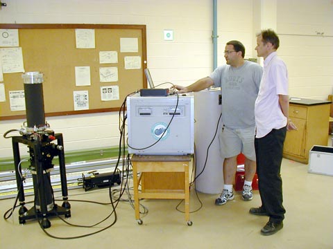
| Jason Silliker (left) gives Dr. Peter Dare a demonstration of the equipment in room A17, Head Hall. |


