| |
||||||
|
|
||||||
![]()
Underlying each geographic database is a coordinate system from which the
position of every point in space can be measured. We will explore the
characteristics of coordinate systems in this chapter.
![]() Read
the coordinates of a point.
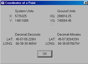
Read
the coordinates of a point.
1. Select the MapQuery > Point Location menu item.
2. Place the crosshair on the spot for which you want coordinates and click on the left mouse button.
3. The readout shows three different measurements: geographic (Lat, Long), ground (XG, YG), and scaled ground (X,Y). The meaning of them will be explained later in this chapter.
4. Click on the OK button to exit from this panel.
5. The crosshair will reappear. Click on the right mouse to exit from this command.
NOTE : After selecting a spot to obtain its coordinates, a cross will be left behind as a reminder. You can refresh the screen to get rid of it by selecting the Draw > Refresh menu item or the Refresh icon on the CARIS Panel.
![]()