![]()
One of the advantages of a GIS is to allow integration of data into a single database. However, there are several factors that could make this a challenging task. In this chapter, we will address several of these factors including differences in data structure, projection, resolution, accuracy, graphic quality, interpretation, currency, and attributes.
![]() Prepare
the FTON file for the exercises.
Prepare
the FTON file for the exercises.
To ensure that you see the proper features on the FTON file in these exercises, do the following.
1. Open the FTON file and click on the Visibility Parameters
buttton or select the Options > Display > Visibility Parameters ... menu item to hide contours from the display. To do this you would choose the contour's feature code to exclude them as was done in an earlier chapter.
2. Exit from the Editor.
Difference in Data Structure
Different GIS could use different formats to store the same geographic feature. For example, one of them might use a vector structure and the other a raster structure. Converting data from vector to raster is simple, but the reverse conversion is complicated.
Converting between different raster formats is not as difficult as converting between different vector formats. This is because vector formats are more complicated, contain more information, and hence have more variations. Depending on the nature and magnitude of the differences, the conversion of data from one vector structure to another is not always easy.
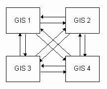
There are two approaches to converting data between different GIS. One is to use a direct translator that converts one GIS structure to another. When there are n different systems involved, we need n(n-1) one-way translators to cover all possible data conversions among them. In this example involving four different GIS, we need 12 such translators.

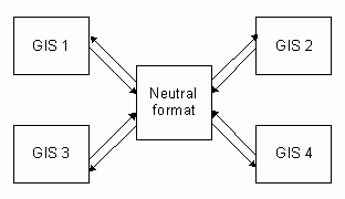
The other approach is to let all translations go through a neutral format, requiring only 2n one-way translators.

The first approach uses direct translators but there are more of them. This is usually not a problem until one of the GIS structures changes, affecting 2(n-1) translators. The second approach involves fewer translators but changing one of the structures affects only two translators. However, all translators are indirect because they must go through a neutral format. Hence the design of the neutral format has significant effects on data conversion.
In theory, the neutral format has to be very flexible and accommodating. A restrictive format, such as one not allowing points to have three coordinates, would cause data degradation during the conversion. But a format that is too flexible tends to be complicated and difficult to use. In reality, several of these neutral formats have been developed, each catering to a group of users with similar requirements.
Most GIS would provide translators to and from a number of these neutral formats. When there is a definite need to convert large volumes of data efficiently from one particular GIS to another, a direct translator between them will be written.
In this chapter, we use a digital topographic map produced by Geomatics Canada that was imported to this GIS through an interchange format called DXF. DXF was originally designed to exchange Computer-Aided Design (CAD) data between AutoCAD applications. As the use of AutoCAD for geographic data capture and editing increases, DXF becomes one of the standards of exchanging data between GIS.
Geomatics Canada used a translator to export data from the National Topographic Database (NTDB) to DXF, and we have used another translator to import data from DXF to the CARIS format. Because DXF was not specifically designed for geographic data, there is some loss of information during the translation process. For instance, DXF does not recognize topology and therefore no topological information is passed to us.
![]()