| |
||||||
|
|
||||||
![]()
This method and the previous one produce identical results. However, the use of zones provides more flexibility - you can create zones with holes, and the zones can be stored away for future use.
In this example, we will use three steps to create a zone with a hole.
1. Create the outer zone.
2. Create the inner zone.
3. Subtract the inner zone from the outer zone to make a ring.
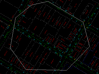
![]() Create
the outer zone.
Create
the outer zone.
1. Pick the Zone > Pixel Resolution... menu item to define a ground resolution of one metre.
2. Pick the Zone > Create > By User Defined Area... menu item.
3. It will be called ZONE_A automatically unless you have previously created a zone with this name.
4. Choose a colour for the zone.5. Use the crosshair to enter the points for the outer zone. Remember to close the polygon you can click C on the keyboard. Enter Y on the keyboard or right click the mouse to accept this polygon.
(288788, 740274), 1:1000
6. A raster zone is created and drawn.
NOTE : The zone will cover the parcels underneath. You would have to turn off the Options > Display > Erase switch and refresh the screen again to show them.
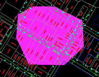
![]() Create
the inner zone.
Create
the inner zone.
Follow the same procedure as in the previous exercise to create the inner zone. It will be called ZONE_B automatically.
NOTE : When you are asked to define the outline of the inner zone, the polygon you have used previously will be highlighted. Enter N on the keyboard to reject it.
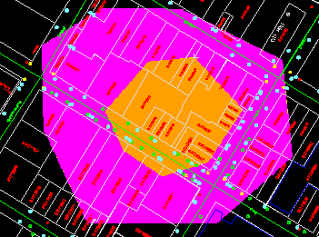
![]() Subtract
the inner zone from the outer zone.
Subtract
the inner zone from the outer zone.
1. Refresh the screen.
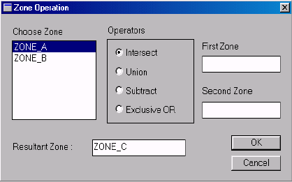
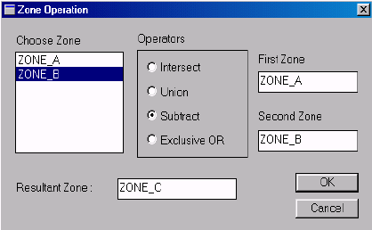
2. Pick the Zone > Operation ... menu item.
3. The Zone Operation panel shows that two zones, ZONE_A and ZONE_B, have already been created. Click on th Zone Operation Panel below to view to entire panel.
4. Click on ZONE_A to select it as the first zone, and then click on ZONE_B to select it as the second zone. Turn on the Subtract operator. This will generate ZONE_C by subtracting ZONE_B from ZONE_A. Click on the Zone Operation Panel below to view the entire panel.
NOTE If you have turned off the Options > Display > Erase switch previously, turn it back on.
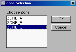
5. Pick the Draw > Zone ... menu item. It shows that we have now three zones. Select ZONE_C and click on OK button
.
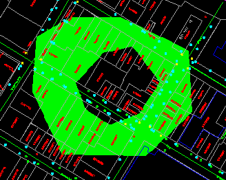
6. Choose a colour.
7. The ring is drawn on the screen.
![]()