![]()
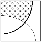
Traditionally, a land use map and a soil map would be placed over each
other on a light table, and we would visually inspect the composite to
look for areas where agricultural lands overlapped fertile soils. This
manual process is tedious and, when many layers are involved, could become
extremely difficult for the human eyes to see through them. In a GIS,
overlaying is done digitally, and many of these restrictions do not apply.
Putting two data layers together to form a composite is only a first step in the overlay analysis. After we have created new areas out of the overlapping regions, we would normally select only those areas of interest to us. For instance, we might be interested only in areas where agricultural land is developed over fertile soil. In another analysis, we might be interested only in areas where agricultural land is developed over poor soil.
A map layer involves different kinds of features. When performing an overlay analysis, we often find it convenient to group features into two classes: those satisfying certain conditions, and those not satisfying the same conditions.
In the land use layer of our example, we are interested in the agricultural lands. So we group all other land use types into non-agricultural lands. Similarly, we identify fertile and non-fertile soils in the soil fertility layer.
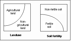
After we have reduced each layer into two classifications, we can perform intersection, union, subtraction, and other logical operations on them. The following shows the results of some of these operations. The intersection shows agricultural land over fertile soil, union shows agricultural land and fertile soil combined, and subtraction shows agricultural land over non-fertile soil.
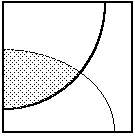
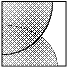

Intersection Union Subtraction
Overlaying does not involve only areas. We sometimes overlay areas upon lines to find out, for instance, how many countries a river flows through. We could also overlay areas upon points. An example would be to determine how many trees there are within a park. In theory, overlaying of points upon points, points upon lines, and lines upon lines is possible. They are less common, and many GIS do not support these options.
In this chapter, we will address the overlay of areas upon areas using data of both raster and vector formats. Other kinds of overlay analysis will be described in the following chapters.
Vector Overlay
In vector overlay, the input layers and the output composite layer are topologically structured. Hence an overlay operation generates new nodes, arcs, and polygons.
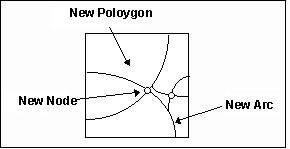
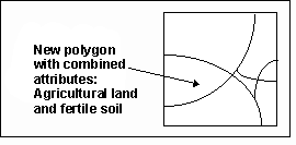
The new polygons will inherit the attributes from the two original layers. For instance, one of the new polygons in our example will have properties inherited from both land use and soil fertility layers. Even an old polygon which was not split during the overlay process will have additional attributes associated with it because it is contained within another polygon from another theme.
Overlay analysis using vector data involves quite a few calculations ó cut arcs from the two layers to form new ones, form new polygons out of the new arcs, and so on. When many arcs and polygons are involved, such calculations are too slow for an interactive environment. In this chapter, we will introduce a simplified version of this that is more suitable for interactive analysis.
Raster Overlay
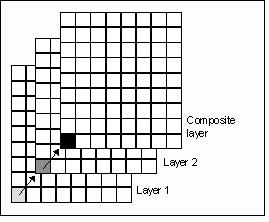
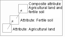
A faster way of performing an overlay is to use raster data. If both raster layers are of the same resolution and their pixels are aligned, then an overlay operation is merely matching corresponding pixels from both layers and combining their attributes to form a new pixel in the composite layer.
This involves no geometrical calculations and no creation of new polygons. Unless the layers are extremely large, overlay analysis involving raster layers can be done interactively.
![]() The
demonstration Concepts: Overlay analysis in Demo 3 explains the concepts
of vector and raster overlay analysis.
The
demonstration Concepts: Overlay analysis in Demo 3 explains the concepts
of vector and raster overlay analysis.
Zone Overlay
A zone is a collection of pixels having the same attributes. In a conventional raster representation, pixels exist independent of each other, and each pixel is associated with a list of attributes. For example, the attribute "agriculture land" is associated with each and every pixel that falls on this type of land use. In a zone representation, all pixels belonging to agricultural land will be grouped together in the file and given the proper attributes only once. This saves us some storage space. Moreover, zones delineate geographical objects such as land use regions.
Zones can be composed of disjoint components, and they can have holes. The zone in this example is composed of two pieces, and one of them has a hole. The resolution for this raster zone is 7.
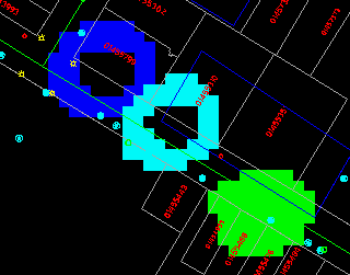
(289000, 739963), 1:700
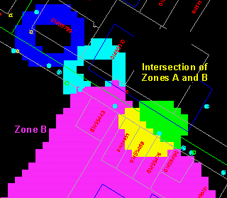
After we have created zones, we can perform overlay operations between them. The following example shows the intersection of two zones.
Zone and Vector Overlay
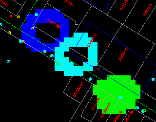
We can also perform a quick overlay analysis of a raster zone over features in vector format. In this kind of analysis, no new polygons will be created, and any polygon overlapping the zone will be retrieved in its entirety.
![]()