![]()
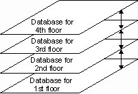
We have so far treated geographic features as being flat. A point can be defined with a third coordinate, thus showing its elevation or depth. But even with three-dimensional points, it is still difficult to show and manipulate solid objects such as multistory buildings. A solution to this is to allow layers of data, such as floors of a building, to be linked so that the user can traverse up and down the chain of databases.

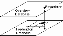
Another reason for chaining databases together is to let a smaller scale database lead to a larger-scale database showing more detail. For instance, a dot representing a city in an overview database could be chained to a large scale database of the city.

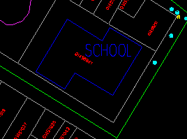
We will show in this example how a school building in the municipality database is linked to its floor plan.
![]() Obtain
the school floor plan.
Obtain
the school floor plan.
1. Select the Draw > Vertical Database > Draw Down One Level menu item and point at the text SCHOOL.

(289034, 739862), 1:800
2. When the name is highlighted, click the left mouse button to confirm.
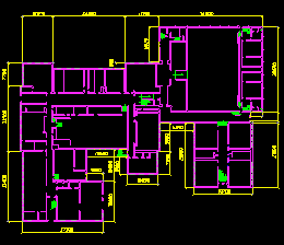
3. The floor plan for one of the floors in the school will be shown.
It is a complete database by itself except that we have not created user-defined attributes for it. We also have not built topology for it. Hence you cannot use the DB Manager to query this database. You could, however, perform measurements such as length and area on it.
4. You can return to the municipality database by selecting the Draw > Vertical Database > Draw Up One Level menu item.
![]() The
demonstration Viewing vertical layers of data: Vertical databases in
Demo 1 shows how to view vertical databases.
The
demonstration Viewing vertical layers of data: Vertical databases in
Demo 1 shows how to view vertical databases.
![]() The
demonstration Viewing vertical layers of data: Vertical databases in
Demo 1 shows how to view vertical databases.
The
demonstration Viewing vertical layers of data: Vertical databases in
Demo 1 shows how to view vertical databases.
![]() The
demonstration Viewing vertical layers of data: Vertical databases in
Demo 1 shows how to view vertical databases.
The
demonstration Viewing vertical layers of data: Vertical databases in
Demo 1 shows how to view vertical databases.
![]()
